In this first part of the GR5 hike, I walked from Saint Gingolph to Les Contamines Montjoie. GR5 stages 1 to 4.
Day 1 – Chapelle d’Abondance : 18.9km 1815mD+
The first day of hiking started late at around 1pm, after lunch. I had a long 4 hours drive to get to the start, the village of Saint Gingolph. I planned a short hike of 18 kilomtres, but I wanted to stop at Chalets de Bise (12km), but could not book the refuge there. I had to then hike to La Chapelle d’Abondance. The ascent of 1,815m made this stage challenging, and I had to push so as to arrive not too late at the hotel.
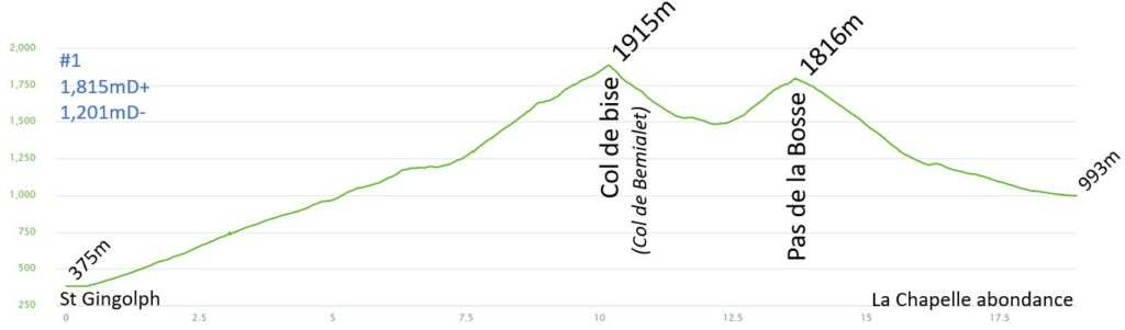
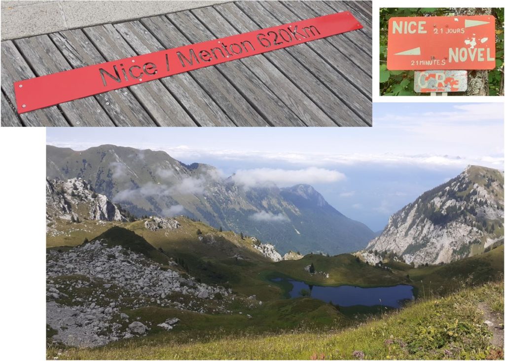
The start of the hike in Saint Gingolph is steep, through the village streets. I arrived quickly in the forest and the first climb was to a little village called Novel. I walked through Novel in less than one hour. I continued to climb, leaving the trees behind. After two hours of climbing, I am out of the clouds, and the lake is already far behind me, and I can see it one last time.
I reached the Col de Bise (1915m) in 2h30. This will be the first Col of this long hike. I stopped few times, but my average speed of 600m/h for these first 1500m D+ was great. I will cross many other cols before reaching the Mediterranean Sea…
My first descent was fast. I reached the Chalets de Bise in only 20 minutes, not bad for 400m of descent. My quadriceps may be painful over the next few days. The 10kg bag pack, will also add some stress to the muscles going downhill.
There was a big party at the Chalets de Bise, music, sunshine, food and drinks. I just filled up my bottle at the fountain, and headed quickly to the second climb. On the way I could hear the accordion playing old songs… It took me 30 minutes to climb the Pas de la Bosse (1816m), and these 300m D+ (same speed of 600m/h). It was a hot day, once out of the clouds.
I just needed to go down to Chapelle d’Abondance to finish this first hiking day. It took me one hour to descend the 800m D- (just over 5km).
The speed of this first day is giving me more confidence about my speed and plan for the next days.
The first day hiking, took 4h30, I arrived at the hotel just before 6pm. I had enough time to get a nice hot shower, get changed and walk to the village to get a big pizza and a beer. I won’t reserve breakfast for the following day, because I will start early tomorrow morning.
I took the opportunity to charge all my electronics, because I was not sure I would have access to electricity for the next few days. I have a 20,000mAh battery bank, it should adequately charge my watch and phone for few days.
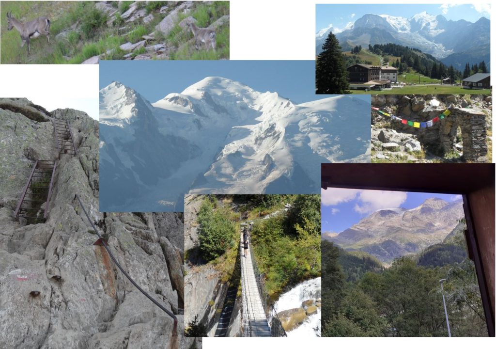
For each hiking day, I tried to combine the best pictures:
Day 2 – Refuge de chardonnière : 33.5km 1991mD+
Day 2 started from the hotel just after 7am. I stopped at the boulangerie for 10 minutes to get breakfast, and a sandwich for my lunch. I started with the long sleeve t-shirt, but removed it quickly at around 8am, as it was getting warm.
The quads were tender after the fast descents from yesterday. I will have delayed onset of muscle soreness for the next few days. It will slow me down on the descents.
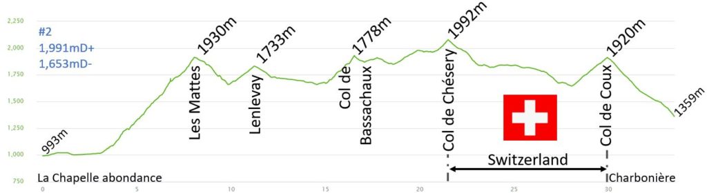
The start of the hike is in the valley of the “Dranse d’Abondance”. After 30min, the path turned right to climb to Les Mattes (1930m). Then the path enters the forest and afterwards continues through mountain grass, where I met hikers who slept overnight in their tent. They were drying their tent in the sun, packing their bag for the days hike. It took me 1h30 to climb the 900m ascent. My climbing speed of 600m/h seems constant at the moment. I stopped a few times to take pictures, and eat raspberries…
Once I reached the col, the rest of the day I stayed at high altitude. It was a succession of short climbs and descents. There were plenty of raspberries and blueberries along the trails which slowed me down as I couldn’t resist eating them!
I stopped 10 minutes at the col de Bassachaux (1778m) to enjoy my sandwich, sitting on the grass, enjoying the view of the Swiss mountains.
After lunch, I started on the wrong path, hiking up the Tête du Lindaret to reach the top of Avoriaz ski pistes. Lots of tourist were using the ski lift to reach the top of the mountains, and I was surrounded by mountain bikers and hikers, which felt strange, after a very solitary morning. I was able to find the GR5, before the col de Chésery (1992m), and I got back on track, without adding too much extra mileage.
I entered and hiked through Switzerland for around 10km. It was a less busy, I met a lot of mountain bikers, and I observed a helicopter hovering, on its way transporting a cow. The cow was hanging from one leg under the helicopter. It was not a common sight! I stopped for a coke in a hut at high altitude. It gave me much needed strength for the last climb of the day to col de Coux (1920m).
Back in France, it took me 45 minutes to hike down to the Refuge Charbonnière. The second day’s hike took 8 hours, and I arrived just after 3pm at the refuge. I had enough time to have my shower, clean my clothes and enjoy a beer watching the cows waiting to get milked.
I had diner at 7pm, and enjoyed my discussions with other hikers who are on the GR5. We were all fresh at this early of our journey… A few of them had big bags between, weighing between 15 to 20kg, which carried their tent, food… Some had planned to hike the entire route in 30 to 40 days and others were only hiking part of it, planning to return next year and complete another part.
The menu at the refuge was fixed, we started with soup (and there was an opportunity to get a second plate), then we had veal with rice (big portions with the opportunity to get an extra small portion), and we finished the meal with cheese and dessert.
The view from the dormitory was amazing, the sunset was changing the colour of the mountain, from a nice orange to a pink colour. Before 10pm, we are all in bed, resting our bodies for the next day of hiking.
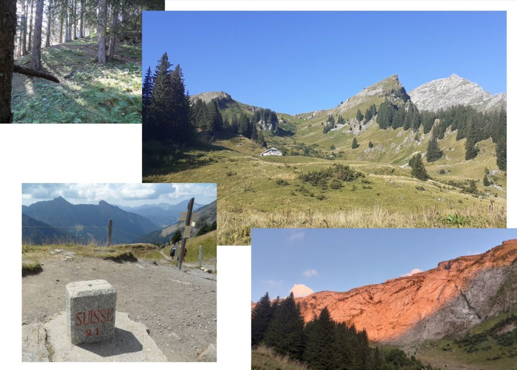
Pictures of the day:
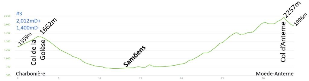
Day 3 – Refuge Moëde Anterne : 33.7km 2012mD+
I woke up at 6.30am, prepared my bag, had breakfast at the refuge at 7am and left just before 7.30am. I should have roughly the same distance/altitude as day 2.
My quads were still tender, it will be another few days at least, before they recover. Normally after a single day’s hike, it takes 3/4 days to recover, but on this 18-day hike, the legs have little time to rest or recover.
From the refuge, I climbed to Col de la Golèse (1662m). I only stopped for a few minutes to remove my long sleeve top. This 30-minute climb was a nice way to warm-up for the days hike.
From the Col, I had a long walk down to Samoëns. I was planning to get a sandwich in the boulangerie, but the GR5 does not go through the village, although it was just 300m away. The route stays along by the river, “Le Giffre”, and then it enters the Gorge des Tines. There are ladders and steps to climb, and there was a detour in place and as part of the path ahead was closed, due to trees falling / dying during the hot Summer. We went to the other side of the river and walk closed to “Sixt-Fer-à-Cheval”.
The first 20km of the day was very fast at nearly 6km/h. I was able to slow down for the last climb. It was nearly 1500m to climb to the Col d’Anterne (2257m). There were lots of rivers and cascades. The road allowed tourist access to the valley. The “cascade du Rouget” is very popular and busy. I arrived quickly at the Chalet du Lignon (1160m), where I stopped for 15 minutes for a sandwich and a coke.
The climb up to the Collet d’Anterne (1750m) is tough. I stopped few times to take pictures of the waterfalls and drank water. Later when in the forest, I could really feel the heat. The watch temperature sensor records 28°C.
After the Collet d’Anterne, the progression onto the plateau was easier. I stopped for another 15-minute break at the refuge Alfred Willis (1780m), to finish my sandwich and fill-up my water bottle, the temperatures was then above 35°C.
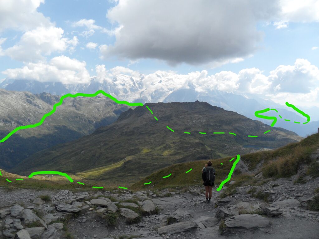
It then took me nearly 1 hour to climb to the Col d’Anterne (2257m), along the Lac d’Anterne. The view to the Mont Blanc Massif at the col is beautiful, unfortunately, it is covered by some clouds, so I could not enjoy it fully:
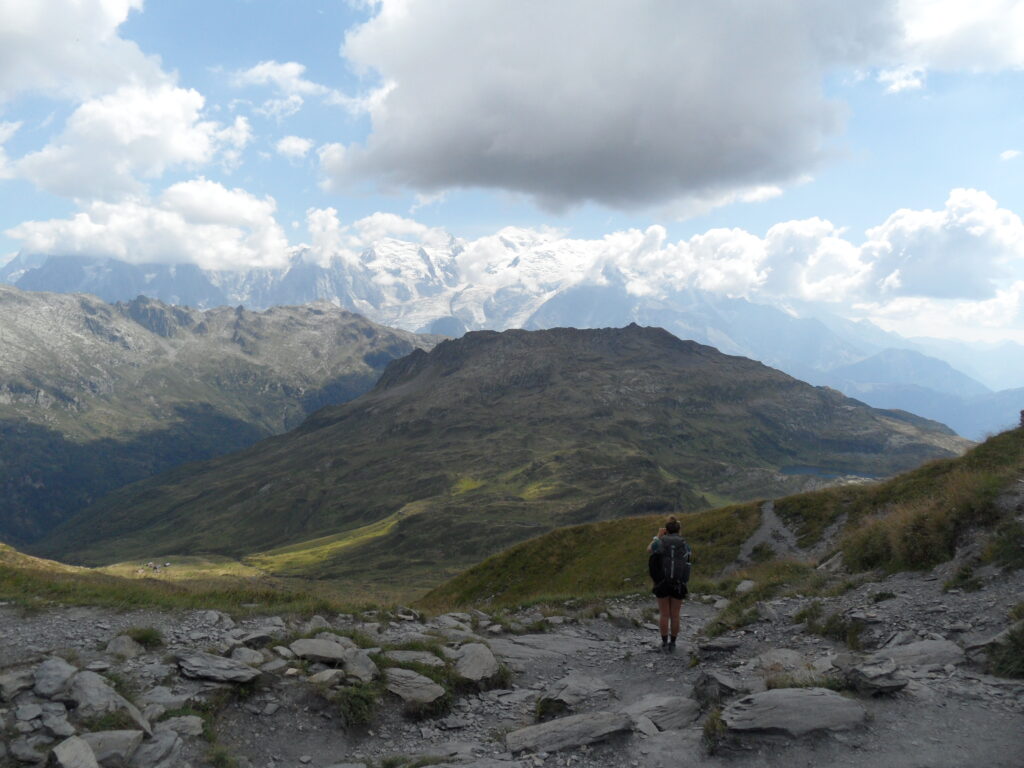
I have a great view of the hike I will enjoy day 4. It is crazy to overview the long hike awaiting to reach Les Contamines:
It then took less than 20 minutes to reach the Refuge Moëde Anterne. It was a 7h30 hike today and I arrived at the refuge at 3pm, same as yesterday. I removed my shoes, put on flip flops and washed my clothes, then it was time to relax with a beer in front of the Mont-Blanc. I didn’t have a shower tonight, the very hot weather this summer had reduced the water supply at this high altitude and there was not enough water in the refuge to open the showers.
The refuge was fully booked with 91 people. There were people camping all around the refuge, but they could not have dinner there as the refuge had reached fully capacity. I had a great diner with Diots (local sausage) and Polenta. The diner was really rich and as usual, I was in bed before 10pm.
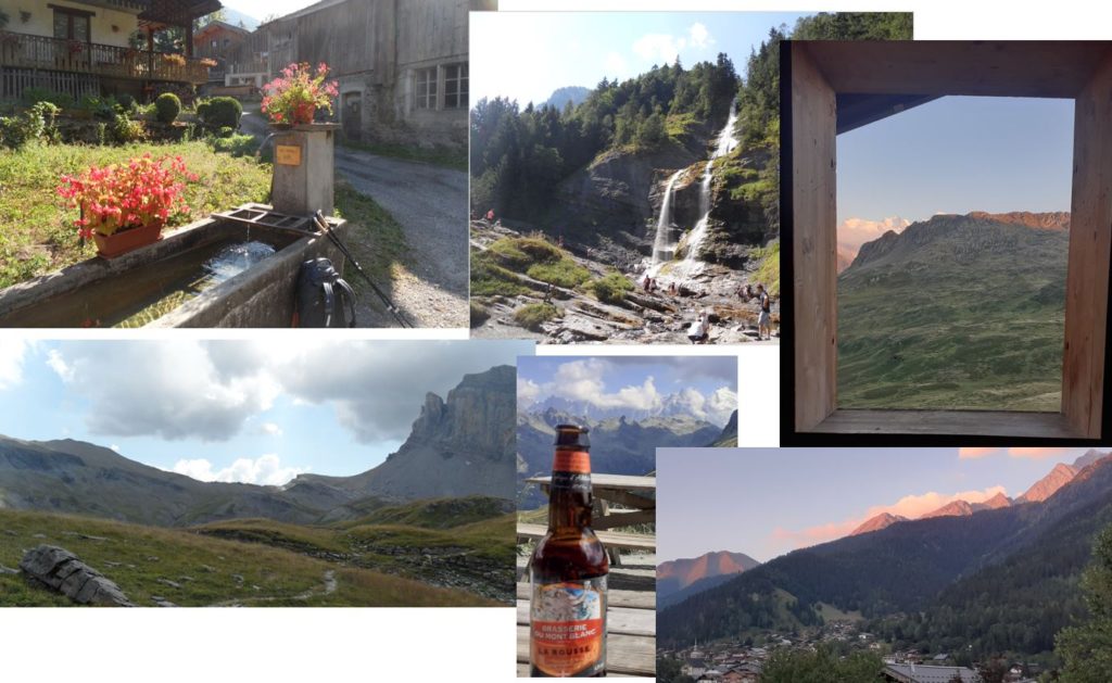
Pictures of the day:
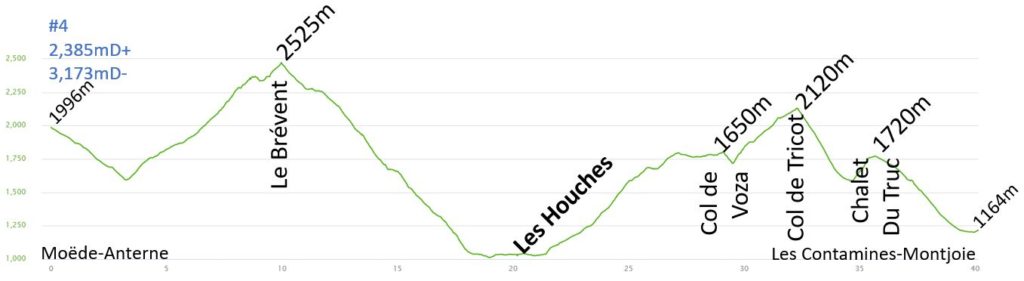
Day 4 – Les Contamines-Montjoie : 40.1km 2385mD+
I was looking forward to this stage. It has a great view of the Mont Blanc, and I already know many of the paths, with a new variant, which I am looking forward to taking.
I really wanted to take this variant to the col du Tricot, it has an extra climb after the col Voza, so I woke-up earlier, at 5.30am, had breakfast at 6am so I could start early, to ensure I had enough time. It was busy in the breakfast room this morning. I had a quick breakfast, to ensure I had enough food for the challenging hike. It was dark but I didn’t need the headlamp.
The downhill start was nice and quiet. My quads still felt a little tight but the pain was not too bad. The sky was clear, but the Mont-Blanc massif was behind the Pointe Noire de Pormenaz. I quickly reached the bottom of the Valley, in less than 45 minutes. There were a few tents close to the river, but not much wildlife, I only saw 1 bouquetin this morning.
At the start of the long climb to Le Brevent (2525m), there is nearly 1000m of altitude climb in front of me, but the view at the top is one of the best of the Mont Blanc. The path was very quiet and I didn’t see many hikers. The first 45 minutes were on the side of the mountain and the climb was gentle. Then the final couloir was steep with many curves and I saw a couple of bouquetins there.
The last 20 minutes are in the middle of big rocks, it was not always easy to see the track, but it was well marked. I’d imagine it would be more difficult in snow… Then there were some ladders to scale for the final climb. I took a moment to enjoy the view, (which was at 9am). It was busy because the ski lift from Chamonix was already operating and bringing tourists up directly, to the top.
Then I started the long descent (1500m D-) to Les Houches. I know this route very well. The descent was quick to Refuge Bellachat, which passes the parc de Merlet (lots of cars and tourists who were visiting the animal park), the Statue du Christ-Roi and the river Arve, before finally arriving in les Houches. The descent took 2 hours. It was very hot, my watch displayed 29°C. I stopped in Les Houches for 15 minutes. I bought a sandwich at the boulangerie, ate half of it, filled my bottle with cold water and added a mineral salt tablet and then headed to col de Voza (1650m).
It took 6km to reach the col de Voza, which started on a busy road. By at mid-day it was nearly 35°C and the heat from the road was tough. The climb was difficult, it took me 1h15′ to climb the 600m. I stopped on a bench to eat the rest of my sandwich and refill my water bottle.
At 1pm, I knew I had enough time to hike and follow the variant. This path to les Contamines is new for me, and I looked forward to exploring it. I continued the climb along the Tramway du Mont-Blanc, (the highest cogwheel train in France: In summer, from the Fayet SNCF station (580m) or the village of Saint-Gervais (820m), the Mont-Blanc Tramway allows you to access the Nid d’Aigle (“Eagle’s Nest”, 2380m) ).
Then I reached and crossed the Tibetan bridge over the Bionnassay glacier, and finished the climb to the Col du Tricot (2120m). The new GR5 path is on the ridge instead of the valley, which has a better view of the Bon-Nant Valley. This route is busy with a lot of hikers. The access is easy from the valley with the different lifts or tramway.
The descent to les Chalets de Miage was very steep, and my quads were starting to ache, and it was very hot. I managed to pass a lot of other hikers, but I was not very fast descending as I would like. There is a nice river at the bottom of this valley. I was tempted to get in the river with the other tourists, but I really wanted to finish the day early. I just stoped to refill my bottle, and pushed on, the last hill of the day.
It was a short steep climb to Chalet du Truc, it took me only 15 minutes. Then I kept pushing and nearly jogged the next 40 minutes to reach Les Contamines. The refuge was just 10 minutes from the centre. At this time, I had no water left, but I did not stop, as all the fountains were off because of the water shortage in the valley.
It was a great stage, I always enjoy hiking in the Chamonix valley, even if many of the paths are very busy, it is always great being able to see the Mont-Blanc and all of its Glaciers. It was a tough day, with more than 40km and 2300m of climbing.
I had a good shower, washed my clothes, (which were full of salt and sweat) and I enjoyed a couple of beers on the terrasse. In the evening, I enjoyed a nice diner with a group from Lyon, my own home town. Most of these hikers were doing the Tour du Mont Blanc and were just starting their hike. The diner was a great version of a Rougail saucisse (spicy sausages which are famous in the Island of “La Reunion”), but with Diot sausages and rice.
As usual, I was in bed before 10pm.
Pictures of the day: