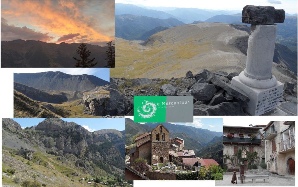
In this fourth part of the GR5 hike, I walked from Larche to Rimplas. GR5 stages 13 to 15.
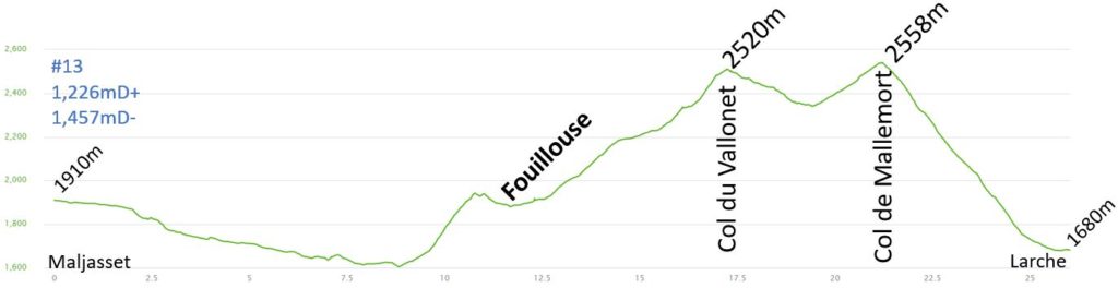
Day 13 – Gite d’étape Le Refuge, Larche : 26km 1226mD+
Day 13 was another short hiking day, and my shin was improving. The arnica gel helped to reduce the pain, and I continued to apply the KT tape to protect the tendon and my shin. It was the exit from the Queyras National Park.
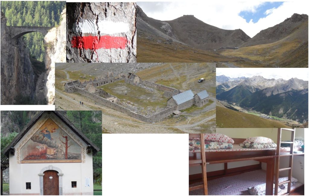
I had an early breakfast and left the refuge at 7:30. The temperature was cold, and I was happy to wear my jacket. The rain from the night before had brought a snow cover to the summits. The first part of the hike was on the road, or sometimes on a small path between the river and the road. The path was very wet, and the rain had increased the flow of the rivers, making my feet and legs wet for most of the downhill. Along the way, I was able to admire old, typical churches, including the Chapelle Saint Antoine, which was particularly striking with its paintings.
In the distance, I could see the bridge (Pont du Châtelet), which was very high above the river, and I knew I had to take it on the way to Fouillouze. The bridge marked the start of a long climb to the Col du Vallonet. The climb began on the road, but soon became very steep as I switched to a path. I arrived in the small village of Fouillouse around 10 AM, when the temperatures were already reaching 25°C. The rest of the climb only got hotter. I continued the ascent on a large path, and this section of the GR5 was quite wild; I didn’t encounter many other hikers. I stopped for a picnic about 200 meters below the summit at around 11 AM. These ten minutes of lunch break were a great opportunity to take in the stunning mountain views and savor the moment.
I reached the Col du Vallonet (2,520m) just before noon, and then began the downhill to the “Vallonet”. This short descent took me half an hour. My shin was continuing to improve, and I was relieved to feel no pain.
I started the final climb of the day to the Col de Mallemort. I passed a large group of hikers, and we encountered a big herd of sheep along with their impressive dogs, under the supervision of a shepherd. This time, the dogs didn’t bother me. Just before reaching the col, there was the Viraysse barracks (1888).
The fort itself was built at a higher altitude of 2750m, and I could see it from the Col de Mallemort (2558m). (For more information, see Fort de Viraysse on Wikipedia).
I could now see the village of Larche, where I would be staying for the night. The downhill took me about an hour on a pleasant path, and it wasn’t as steep as the previous day. My body and shin were in good shape after this 6-hour hike. I stopped at a local shop to treat myself to an ice cream before reaching the refuge just before 2 PM. I spent the rest of the day washing, resting, and enjoying some local beers.
I began planning for the coming days. At that point, I had covered a distance of 400 km (250 miles), and I had 200 km left to reach Menton or 170 km to reach Nice. I initially considered finishing the hike in 17 or 18 days, but I realized that 17 days was not realistic. However, hiking 40 km a day would allow me to reach Menton in 18 days.
Pictures of the day:
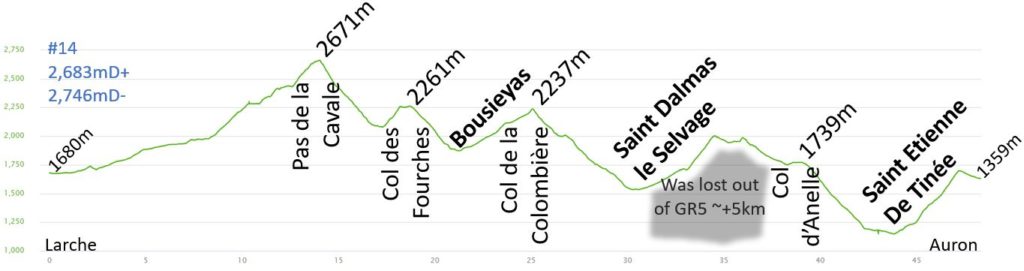
Day 14 – Auron : 48.3km 2683mD+
Initially, I had made a reservation to stay in Saint Dalmas le Selvage, but as my body felt good, I decided to push on and reach Auron with a 42 km hike. Most of the day, I had no phone network, making it difficult to cancel and book a hotel for the evening.
Initially, I had made a reservation to stay in Saint Dalmas le Selvage, but as my body felt good, I decided to push on and reach Auron with a 42 km hike. Most of the day, I had no phone network, making it difficult to cancel and book a hotel for the evening.
I had a quick breakfast at 7am and hit the road promptly. The journey consisted mainly of a 5km road with a 200m climb to reach the parking lot. Some people from the refuge opted to hitchhike to bypass this portion of the path.
It was a beautiful day with a clear blue sky and hot temperatures. The small valley where the trail began was lovely and not too steep. I made quick progress and covered the first 10km in under 2 hours, reaching Lac du Lauzanier. A couple was having coffee while their tent dried from the night’s condensation, and a few marmots were basking in the morning sun after a chilly night. I circled the lake and missed the GR5 markers when I climbed too far to the right. I had to make a steep ascent to rejoin the trail. The remaining 400m climb was challenging, leading to Pas de la Cavale (2,671m). I was alone and only encountered one hiker at the summit, taking in the view. It was only 10am, but with 28km left to go, I couldn’t linger for long.
I began the steep descent, and my shins held up well. Other hikers were either going down or ascending to the col. It took me half an hour to reach the river after a 600m descent. I was able to pick up speed on the way down, making it a more enjoyable experience. My body felt stronger.
There was a brief ascent to Col des Fourches (2,261m), which was dotted with many war bunkers. A lot of tourists visited the bunkers, as there was easy access from the nearby road and a close car park at Camp des Fourches, which was once a barracks for the French army in the late 1800s (as per Wikipedia: Camp des Fourches).
The descent to Bousieyas was quick once again, taking me less than half an hour to reach the village. There was a bar and a fountain where I refilled my water bottle. I treated myself to a coke and enjoyed half of my picnic. Unfortunately, there was no cell service, so I was unable to book a hotel for the night. It was 11:30am, and I had already covered 21km, so I knew I needed to keep going.
I continued with the ascent to Col de la Colombière. The trail was wide as I made my way to the col and it took me about an hour to cover the 5km stretch, which involved a climb of 450m. It was another hot day, with temperatures reaching 30°C.
As I descended towards Saint Dalmas le Selvage, I encountered a large number of wild lavender, and the fragrance was incredible. I was also reaching one of the lowest points of the day, where it was very hot. There was a celebration taking place in the village, and all its residents were having lunch in the central square. I made a quick stop to refill my water bottle. With all the tents set up for the party, it was a bit challenging to locate the GR markings. I eventually found the signs as I was leaving the village. I took a moment to finish my sandwich and was ready for the final stretch of my hike.
However, after about a kilometer, I realized I had taken the wrong valley as the “red/white” markings were not for the GR5. I saw a sign pointing towards Col d’Anelle 200 meters ahead. I decided to make a detour and ended up hiking an extra 5km and 200m of climbing. It was a very long day, one of the longest I’ve ever had.
I tried to reach my destination before it got too late, but I had to rely on my watch and guidebook to find my way. There weren’t many signs, and the forest had many paths. I finally arrived at the Col d’Anelle (1,739m) around 3 PM, but I still had over 10 km to go before reaching Auron.
I pushed on down to Saint Etienne de Tinée. It took me 45 minutes to descend the 500 meters over 5 km. I was glad that my body was still in good shape despite the long marathon. The GR5 passes through the village, but I only stopped to refill my water bottle and didn’t encounter many people there.
Leaving the village, I walked on the road for about 30 minutes before reaching a short but very steep ascent to Auron. The 500m climb was compressed into just over 2 kilometers, and although it was nice in the forest, I was very glad to see the start of the village of Auron.
I reached the hotel at around 5:30 PM, just in time for a shower and some food shopping for the next day’s sandwiches. After such a long day of hiking, the beer and raclette were a real treat!
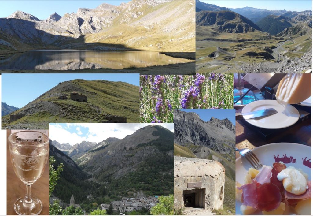
Pictures of the day :
Day 15 – Rimplas : 45.4km 2315mD+
I booked a stay at another hotel in Rimplas, which will require another long hiking day. I had entered the Mercantour area. This was the last day on the GR5 trail, and the following day I had to decide whether to go directly to Nice or take the Mercantour parc and finish in Menton. It was Saturday, August 20th, and the mountains were likely to be busier than they had been in the past few days…
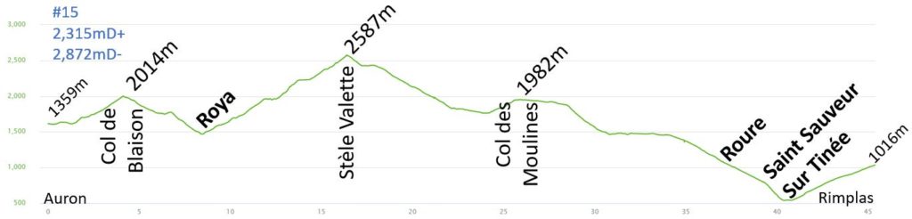
I grabbed a coffee before starting the hike, which was great. At exactly 6am, I began the hike with my headlamp.
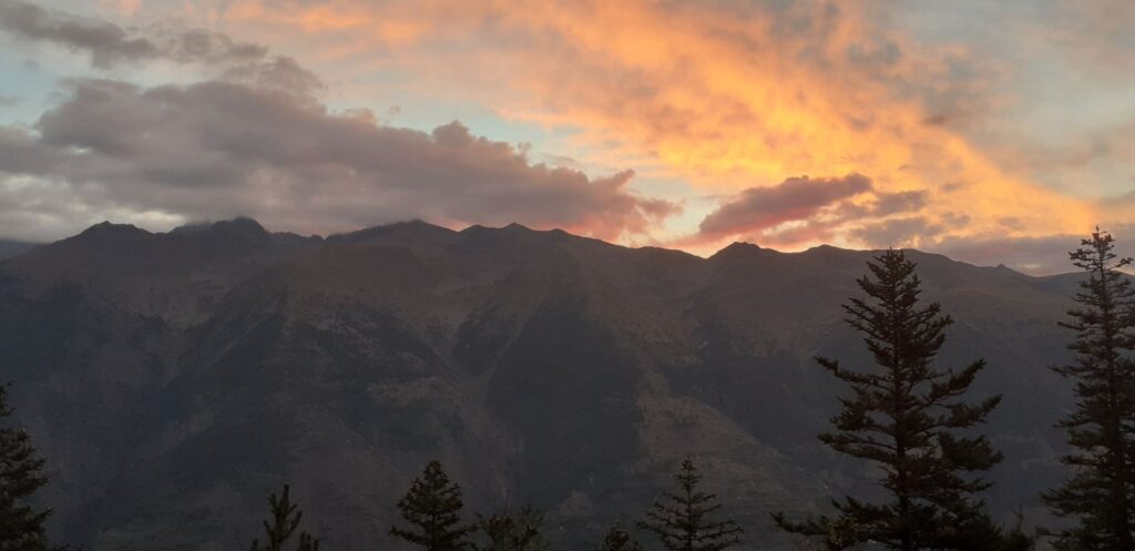
I couldn’t see the start of the hike on the ski slopes, but that’s usually not the best part anyway. However, when I reached the top, I encountered a bouquetin and the sky was painted a bright orange. I was able to turn off my light at Cold de Blaison (2,014m) and start the descent to Roya. I had heard the name of this village before, but it was my first time visiting and it was so small!
It was 8am, and some hikers were packing up their tents or having breakfast. I continued to the bottom of the valley, which was refreshing. I enjoyed the start of the climb, which began in a narrow valley called Vallon de la Maïris. The valley was steep and the river was low under the path. As I left the canyon, the mountains opened up to a large grassy area with thousands of sheep and many aggressive shepherd dogs.
The sun was starting to warm up. I had a difficult time with all the dogs and had to stop frequently during the climb or veer off the path to avoid them. The climb was slow, and I finally reached the Col de Crousette. However, the climb wasn’t over yet. I finally reached the Stèle Valette (2,587m) at 10:30am, but it had been a slow start with an average speed of only 3.6 km/h for the first 16 km of the hike.
The view from the summit was fantastic, offering a 360-degree panorama. I took a brief break to enjoy it after the stress of the climb. The long descent was very hot, and the temperature continued to rise, reaching 36°C according to my watch. The descent started in the grass and, as I approached 2,000m, I reached the Col des Moulinès and the tree line. I took a quick break and chatted with a woman who was taking a break, seated in the grass and eating. She told me that I would be hiking near the charming village of Vignols.
I continued the descent and refilled my water bottle in the river. My water filter allowed me to refill in rivers, and I was able to avoid getting sick during the trip. I stopped to eat my sandwich around noon. It was hot, but I needed to maintain my calorie intake for this long hiking day. The GR5 route went just a little north of Vignols, climbing to the Col des Moulines (1,982m). During the final climb, I could really feel the heat from the cliff.
I arrived at a nice, flat pasture area with cows. The sheep were higher up on the mountain, and the dogs were quiet. I saw many cows and donkeys, and the marmots were sunbathing and playing together. I reached the Refuge de Longon, but it was closed for renovation during the summer of 2022. The rest of the descent to Roure was through the forest, which provided welcome shade on this hot day. The beginning of the descent was enjoyable, with a single track on a steep hill. Then, it became a wide dirt road through the forest, where only a few jeeps were driving.
The small village of Roure was relatively quiet, but I was able to refill my water bottles near the graveyard/church. A helpful tip is to go to the graveyard for access to a water tap. From Roure, the rest of the day’s program was clear: roughly 9 kilometers with a 500 meter descent to Saint Sauveur sur Tinée in the valley, followed by a 500 meter climb to Rimplas. I arrived in Roure just before 3pm, crossed the village of St Sauveur sur Tinée one hour later, and completed the hike in Rimplas just before 5pm. I even had to wait ten minutes for the hotel to open.
As usual, I cleaned my clothes, took a shower, and took a short walk in the village before dinner. My body was now used to the hikes. Although my ankle was still slightly inflamed, the pain had subsided.
Pictures of the day :