In this third part of the GR5 hike, I walked from Modane to Maljasset. GR5 stages 9 to 12.
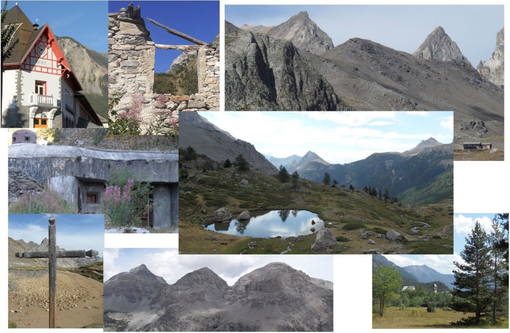
Day 9 – Plampinet, Nevache : 33km 2052mD+
Day 9 was the most important of this GR5 hike. I was not sure if I would be able to continue due to the inflammation of my shin. Although my ankle was also inflamed, I was able to put it inside my shoe and manage the pain. I was more confident that it was a shin splint rather than a stress fracture, and the KT tape strap should help support my shin. The sun was shining, and I was looking forward to the next few days of hiking. I am familiar with this area of the Alps as I used to live in Torino, just 100 km away.
I had a late breakfast at the hotel and started hiking just before 8 am. After a brief walk in the city of Fourneaux, the trail quickly climbed into the forest, passing under a motorway bridge. I arrived at the ski station of Valfréjus (1,550m) in just 1 hour and 15 minutes. My shin and ankle were painful, especially when I stepped on a root or stone. However, the pain was much less severe than the previous day.
The trail was quiet at the moment, but there were many cars driving on the forest road on the other side of the valley. It was August 15th, a bank holiday in both France and Italy. With the hot summer weather, many people were taking advantage of the opportunity to head to higher elevations in the mountains to escape the heat in the valleys.
There are a lot of military forts / cannons in these valleys. France and Italy were fighting to keep the control of the region between 1883 and 1947. It was always impressive to see these forts where young fighters were spending months. The car park at the end of the dirt road was full and the rest of the hike was on very busy trails. Big group of friends or families are hiking to the Thabor summit (3,178m altitude).
The ascent was rapid, and by 11 am I had reached the Col de la Vallée Etroite (2,434m), having already climbed 1,400m. I was disappointed to see that the small lake at the top was completely dry. This was the first time I had seen it this way, despite having climbed to this location multiple times in the past.
The descent into the Vallée Etroite worsened the pain in my shin, but I still enjoyed the familiar path. I encountered a couple of Italians who were on their way to the Thabor. They had missed the sign at Lac Vert and were on their way to the Col, which would have added a significant extra loop to reach the summit. I watched them walking down 15 minutes later and decided not to continue on to the summit.
The path near “Lac Vert” was packed with people, including many children running around. So many people had come to this part of the mountain for their August 15th picnic. I reached the Granges de la Vallée Etroite, where the refuges were all bustling with activity. I turned right 100 meters too early, adding about 1 km and a 50 m climb. The correct turn was just in front of the “Refuge Terzo Alpini.” This part of the hike is in France, but access is easier from the Italian side, and most of the refuge names are in Italian.
The trail quickly climbed back into the forest, and it was busy with traffic. I had to pause to let a couple riding horses pass by. After 30 minutes of climbing, I stopped for a sandwich just in front of the “3 Kings” (Re Magi), a unique mountain range between Italy and France.
This part of the hike was new to me as I had previously parked in the valley. The climb took me up to the Col des Thures (2,194m), where I discovered a beautiful lake and had a view of the Névache valley and its distinctive mountains.
It was hot even at an altitude of 2,100 meters. The next three kilometers were nearly flat and were completed quickly. There was a variant that descended directly to Névache, but I continued on the path leading directly to Plampinet.
There was a long descent into the Clarée Valley in the forest. I could feel pain in my shins. After a seven-hour hike, I was starting to feel tired. The scent of the mountains had already changed; the pines were different, and the heat and smells indicated that I was in the southern Alps. Although the journey was far from over, I was getting closer.
The last 20 minutes of the hike were flat and took me between the road and the Clarée River. I arrived at the refuge at 3:30 PM.
I took a shower, washed my clothes, and enjoyed a beer in the garden while chatting with other hikers. In the evening, I had the pleasure of having dinner with my good friend Franco, who had driven from Turin.
I was overjoyed to see my old friend and to find that my body was capable of hiking so many kilometers. In the coming days, I will be taking shorter hikes to recover and be able to make it to Menton before my return flight.
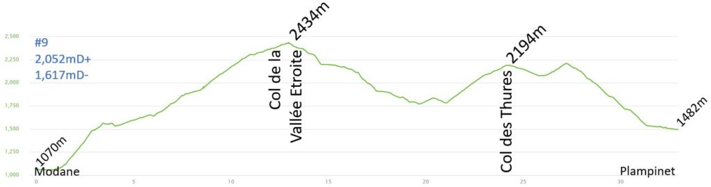
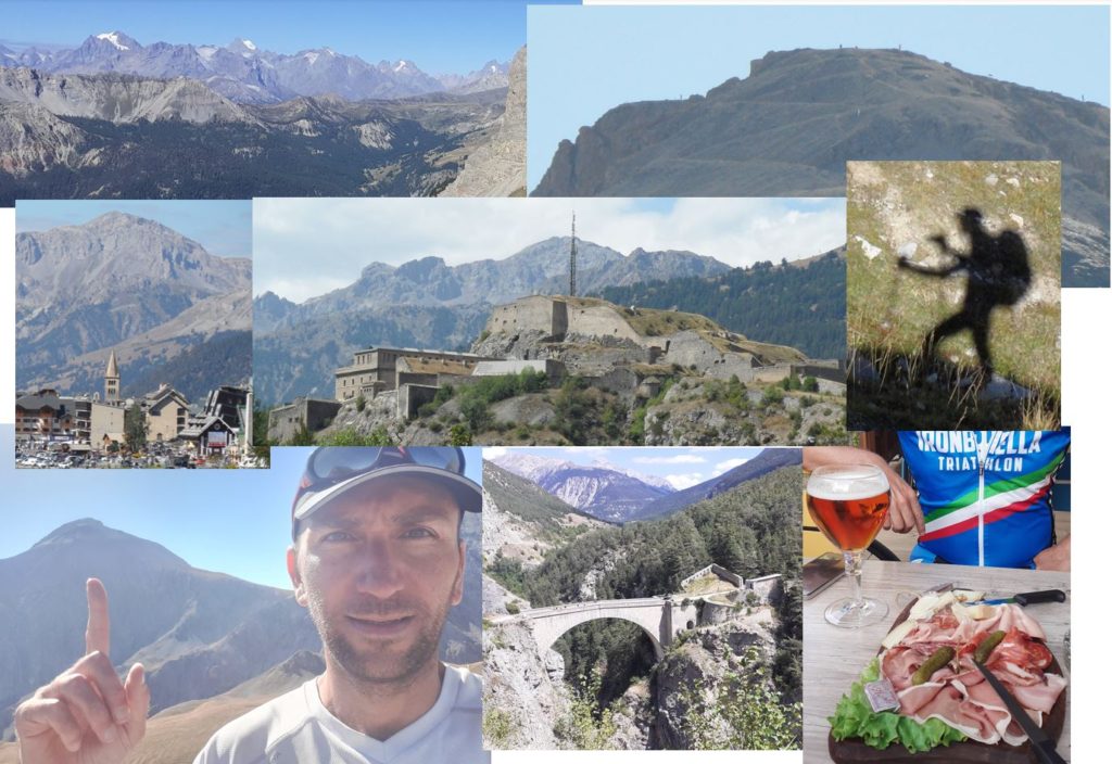
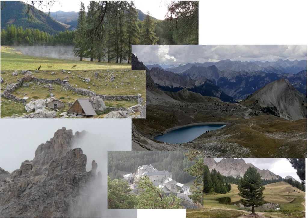
Pictures of the day:
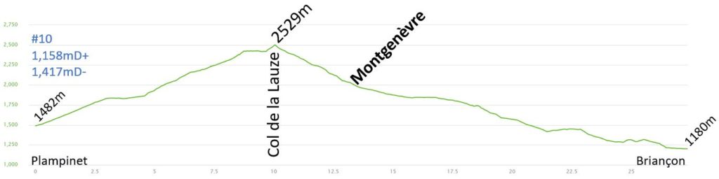
Day 10 – Briançon : 27.4km 1158mD+
I booked a hotel in the center of Briançon to keep this stage at just under 30 kilometers. I know this stage very well and will pass just below Chaberton (3,131 meters). I have climbed this mountain many times in the last 20 years. Initially, I had planned to reach the summit of Chaberton, but with my inflamed shin, I decided to forgo this extra effort and allow my body to heal. The route was straightforward, with a climb to the Col de la Lauze and a descent to Briançon. I did not bring a picnic and planned to stop for lunch in Montgenèvre in the middle of the descent.
Most of the hikers were ready to go and were waiting before breakfast, which began at 7:30 AM. I had a quick breakfast, my bag was ready, and I was the first to start.
My ankle was still inflamed, but the pain had decreased. The KT tape was still providing protection to my shin.
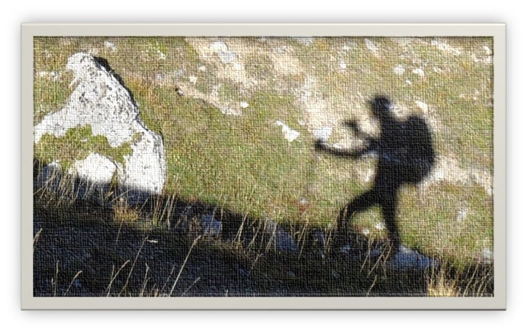
I had a solitary climb to the Col de la Lauze. The start was on a wide dirt road, and I took in the view of the valley. The altitude gain was gradual because the road was not very steep. It took about an hour to reach the Chalet des Acles after a 400-meter climb. I turned right onto a path I had taken before for the final climb to the col. It became steeper, first in the forest, then along the Vallon de l’Opon in the grass. The sun was already high, and I could see my shadow as a hiker. I could also see the summits of the Ecrins and their glaciers. I reached the Col de Dormiouse and the final climb to the Col de la Lauze (2,525 meters), which I reached just after 10:00 AM. I did not see anyone this morning.
I took this great picture on my way up:
I could finally see the Chaberton, a famous mountain located between France and Italy. Italian troops built an artillery battery on its summit between 1898 and 1910, which was comprised of 8 towers and pointed towards France. I have witnessed many sunrises from its summit.
I began the descent and started encountering hikers. A few of them were on the GR5, but most were on a daily hike from Claviere (Italy) or Montgenèvre (France). I have loved this valley since I started hiking here in 2001. It took me an hour to reach Montgenèvre, which is at 2,000m. Although I felt some pain in my ankle on the downhill, it was manageable.
I stopped at the local bakery to purchase a delicious sandwich, which I enjoyed while sitting on a bench in the sun.
Looking down the valley, I could see Briançon, but it was the first time I had hiked this route. During the summer, there was a golf course, making it tricky to find the path. I started the descent along the main road, but after passing the golf course, I took a small trail to the left, reaching a small path in the forest. The descent through the forest was nice and cool. Although there were many paths in the area, they were always well-signed. After 1 hour and 30 minutes, I arrived at the Pont d’Asfeld (opened in 1734), a historic bridge over the Durance, where people were bungee jumping. The entrance to the old city of Briançon was impressive. The citadel was designed by Vauban and built in the 18th century. The final 2 kilometers of the hike were on city streets and parks.
I arrived at the hotel at 2 PM. My body was healing well, but now my backpack required some attention as well. A few of the threads on the shoulder straps were in need of repair. The road to the sea was long, and I needed the bag to hold up. I went to the local supermarket to get a needle and thread, and spent some time in the afternoon repairing the bag.
In the late afternoon, I shared a couple of beers with my friend Franco. He was another Franco from Turin who had come from Bardonecchia by bike. He was training for the Ironman in Vichy. It was another great afternoon with a good friend.
In the evening, I treated myself to a meal at a local pizzeria, including a delicious ice cream.
Pictures of the day:
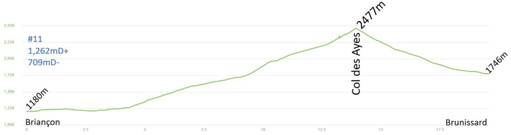
Day 11 – Brunissard : 19.6km 1262mD+
A short 18 km hike was taken to ensure my shin was healing. The hike included a 1,300 meter climb to the Col des Ayes, followed by a 700 meter descent to Brunissard.
After a 7 AM breakfast, I started my hike in the streets of Briançon. After 500 meters, I was unable to see the GR (Grande Randonnée) signs, but locals informed me that I needed to continue on that path. I soon realized that I was climbing up the wrong valley (Cerveyrette instead of Torrent des Ayes). I checked my position on my phone and discovered that I was already off the route. I had already walked an additional 2 km.
I eventually found the correct road, but a van was blocking the next sign. I then reached the next roundabout, but couldn’t see any sign. This time, I decided to go back down and investigate the previous crossing.
Leaving Briançon proved to be challenging. It was always more difficult to find the correct route in larger villages.
It took me nearly an hour to exit the city. The climb in this valley was very gentle, and I didn’t see anyone. After the 15th of August, the paths were less crowded compared to the previous week. I was hoping to see more wild animals.
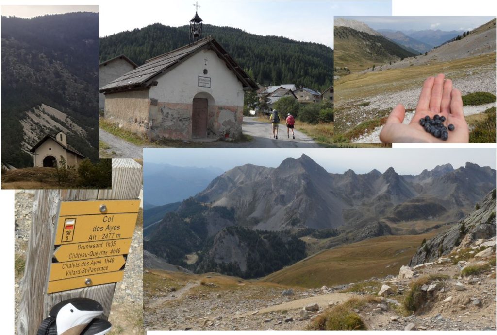
Just before reaching the Chalet des Ayes, I encountered a Spanish couple that I had previously met in Plampinet. They are also on the GR5 trail. The village is quite charming. I took a break to snap some photos and refill my water bottle. The final stretch of the climb to the Col des Ayes is through grassy terrain. I took another break to feast on an abundance of blueberries. The weather was cloudy, and the temperatures were comfortably cool. I arrived at the Col des Ayes (2,477 meters) at 11:00 AM.
The descent was steep at the outset, and the pain in my shins was particularly noticeable today. I was relieved that the stage was shorter in length. I hoped to reach the refuge before the rain started. After navigating a steep, single track downhill, the dirt road widened and became less steep. I arrived in Brunissard (1,746 meters) at 12:00 PM.
I had my lunch directly at the refuge. I did not wash my clothes, as the hike was relatively short and I did not perspire much due to the cloudy weather. In the afternoon, it began to rain. I used the rest of the day to give my body a much-needed break.
In the evening, most of the other hikers were either on the GR5 trail or doing the Tour du Queyras. We had engaging conversations with other hikers and learned about their motivations for undertaking the route. I was particularly impressed by a Dutch man. He had started his journey a few years ago in Holland and had been completing parts of the route each summer. This year, his goal was to reach the sea. He was not a fast hiker, and carried a heavy backpack, but his determination was impressive. He planned to stay two nights at the refuge and take the following day as a rest day.
I retired to bed early in order to aid in the recovery of my shins.
Pictures of the day:
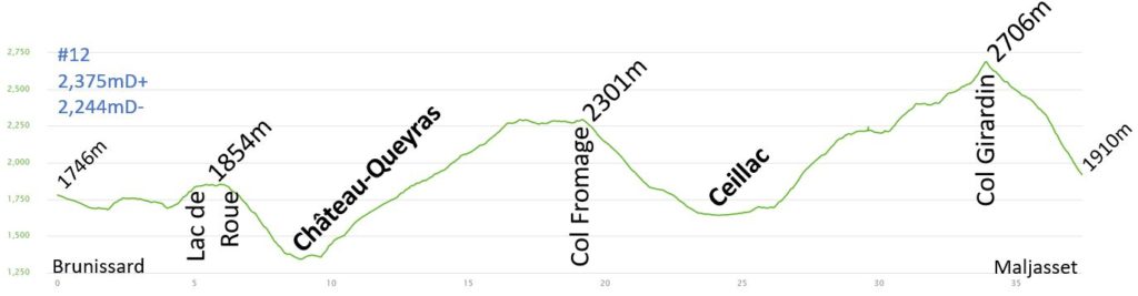
Day 12 – Refuge CAF de Maljasset : 37.4km 2375mD+
I had planned a long hiking day of more than 37 kilometers and three cols to conquer. I hoped my body would be able to withstand the longer hike.
I was able to enjoy an early breakfast at 6:30 AM and set out on this long hiking day in the dark. I wanted to start early and have the flexibility to take breaks during the day in case of shin pain. Although my ankle was still inflamed, the pain was manageable in the morning. The initial portion of the day was spent on roads or relatively flat trails. Due to the rain from the previous night, the tops of the mountains had a thin layer of fresh snow. I arrived at Lac de Roue around 8:00 AM. There were many tourists camping or sleeping in vans. The morning mist rising from the lake was quite mystical. The air was fresh and most of the hike took place within a forest.
The steep descent to Chateau Queyras was completed in just 30 minutes. However, it was difficult to see the castle as the view was obstructed by trees. I chose not to stop and visit the village or castle and continued on the GR5 towards the next climb. I was familiar with this path, as I had hiked a portion of the Tour du Queyras in July of 2010. The day was cloudy, with the clouds clinging to the mountains. It was quite beautiful to see the peaks partially shrouded in cloud. The climb was long, with an elevation gain of 1,000 meters, but I persevered and it took me approximately 2 hours and 30 minutes. At the top of Col Fromage, there was a lovely overlook that offered stunning views of the surrounding mountains.
The descent to Ceillac was quick, and I arrived in the small village within one hour. It was market day and the area was bustling with activity. After a cloudy morning, the sun was now shining and warming up the valley. I continued on the local road, passing beneath the gliders of the parachuters. Despite some fatigue, my body was holding up well, and I still had a long way to go to reach the refuge, with 14 kilometers remaining.
I took a 30-minute walk in the valley, and the circus was advertising their evening show with loudspeakers on top of their cars. The loud music wasn’t exactly relaxing, but it did provide some entertainment for my brain…
The ascent to the next pass is very steep once again. The climb to Col Girardin was a 1,000-meter ascent. The beginning of the climb through the forest was lovely and quite busy, with local tourists hiking up to Lake Miroir. It took roughly an hour to reach the lake from the valley. The trail was busy, and I stopped for my picnic, which I had purchased at the refuge that morning, around 1:30 PM.
I continued my climb to Lake Sainte-Anne and had a close encounter with a Patou dog, a breed of shepherd dog used to protect sheep herds. These dogs are impressive with their collars full of nails. The herd was about 50 meters away, but the dog approached to check if I posed a threat to the sheep. It came barking and stopped only 50 cm away from me. I was able to see all its teeth clearly. I wasn’t very calm, and my heart rate increased to 250 beats per minute! The dog eventually left after determining that I posed no threat to the herd. I was then able to complete the climb to Col Girardin (2,706 meters) and enjoy the view of Lake Sainte-Anne. The climb from Ceillac took me nearly three hours.
From the summit, I could see the small village of Maljasset in the valley below. I didn’t linger at the summit for long and began the steep descent. The path was very steep, and the pain in my shins was intense. I was eager to reach the refuge. It took me one hour to descend the 800 meters. I had to put on my rain jacket as the rain started. I was fortunate to finish the hike before the rain became too heavy.
I enjoyed a warm shower, removed my kinesiology tape, and applied some anti-inflammatory gel to my shins and ankles. The ankle was very inflamed. I relaxed with a beer in the refuge and planned for an easy day ahead, with only 26 kilometers on the itinerary, to allow my shins to recover.
The rain was very heavy all evening and night, and I was grateful to be sleeping in the refuge rather than a tent. We had a great dinner, discussing our daily hikes. Many of the hikers were on the Queyras Tour (GR58) or en route to Italy.
Before going to bed, I applied more anti-inflammatory gel. I also cut the kinesiology tape to the proper size, ready to be applied the following morning.
Pictures of the day:
———– TO BE CONTINUED ———–