In this second part of the GR5 hike, I walked from Les Contamines-Montjoie to Modane. GR5 stages 5 to 8.
Day 5 – Refuge de la Balme Tarentaise : 33.7km 1815mD+
I started at 7am after eating breakfast in the refuge. My body was still in a good shape and my quads were improving, (although it took them 3 days to recover) they were ready for a long day’s hike. The first part of the hike was busy on the route of the Tour du Mont Blanc, but the uphill path was wide. The rest of the day was quieter, with the majority of tourists visiting the plan de La Lai.
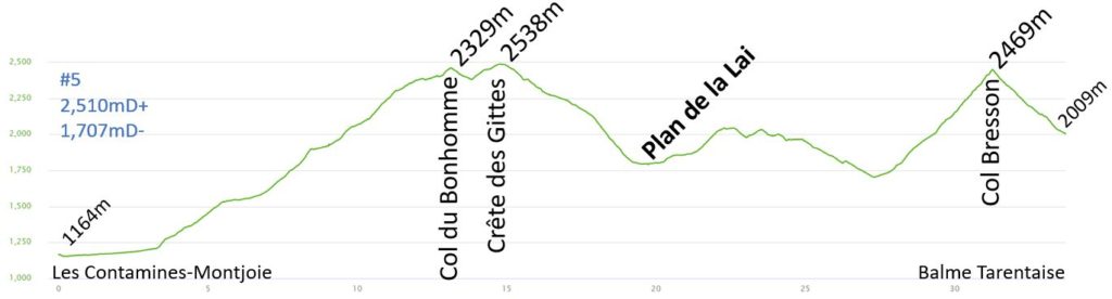
The beginning of the route from the Bon-Nant valley was very flat so I was able to walk quickly, and I was cruising at more than 6km/h. Just before the start of the uphill, I could hear a trail runner, behind me. It was Jim Walmsley training for the U.T.M.B 100 miles (his training session of the day on strava). He was starting to use his sticks at the beginning of the climb. His stride was impressive.
My pace slowed down going uphill, it took me roughly 3 hours to reach the Col du Bonhomme (2,329m). The path was very busy, but my way was never obstructed as the path was very wide. There was just a small patch of snow off the trail, which made for a nice picture. There was a short descent to reach the Refuge du Bonhomme, which was very busy with hikers, so I just stopped to fill up my water bottle. It is a very popular part of the Tour du Mont Blanc. The rest of the route was not as busy.
After one last look at the Mont Blanc, I turned right to descend to the Plan de la Lai. There was still a small climb to reach the Crête des Gittes (2,538m), and after this short climb there was a really enjoyable downhill. I saw only a few hikers on this part of the trail, but it was very busy when I reached Plan de La Lai, as it can easily be reached by car, and the carpark was full. I stopped to enjoy my sandwich and refilled my water bottle.
It was another hot day, more than 30°C. I was moving fast on this part of the hike, with a great view of the Roselend Lake. This part of the trail was also busy. At the Lavachay chalets, I could see the Col Bresson ahead, but I missed the path which left the road on my left, and I continued on straight ahead instead. I stopped few times to check the guide / map, but I didn’t figure out that I missed the turn until I saw other hikers on that path. I went all the way down to Treicol, which added on an extra 150m decent and 150m climb.
The 800m climb to Col Bresson (2,469m) was long and tiring in the afternoon heat. It took me 1h30’ to reach the col, there were plenty of blackberries along the way and the views were impressive, especially looking up from the foot of the Pierra Menta. This summit is very famous in the popular “skimo” race.
From the col, the descent to the refuge was very quick. It took me only 40 minutes to descend 450 meters. I arrived early at the refuge, and I had enough time to enjoy a warm shower, clean my clothes and enjoy a beer on the terrasse. It was another great day’s hike.
There was a water drought this Summer 2022, and it was an even bigger problem / water was scarcer at 2,000m altitude. The only source freely available was not drinkable and could only be used for showering. The refuge had to supply / sell mineral water instead. We had a good dinner with local families visiting and a couple of mountain guides who came to do some rock climbing. As per usual, I was in bed before 10pm.
By day 5, I have learned to organize my backpack even more efficiently, I did bring 1 or 2 pieces of extra clothing, but it is better to be comfortable, and they didn’t weigh much. In saying that, you need to think carefully about what you bring, as you will be carrying it for over 600km. Every night I packed my bag in preparation for the morning, so I was able to get dressed in the morning, (normally in a dormitory) without having to use my headlamp and disturb other hikers.
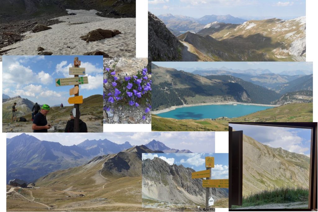
Pictures of the day:
Day 6 – Refuge d’Entre le Lac : 32.8km 1569mD+
During the night, an older gentleman was snoring in my shared dormitory and his grand-children were whistling to try and make him stop. This woke me up many times but I managed to get some sleep. I enjoyed an early breakfast at 6.30 a.m. and started hiking at 7 a.m. It is better to start early, (avoiding the afternoon storms) and finish early. This day’s hike encompassed a long downhill to Landry with a long uphill climb to the refuge Entre Le Lac (2,155m).
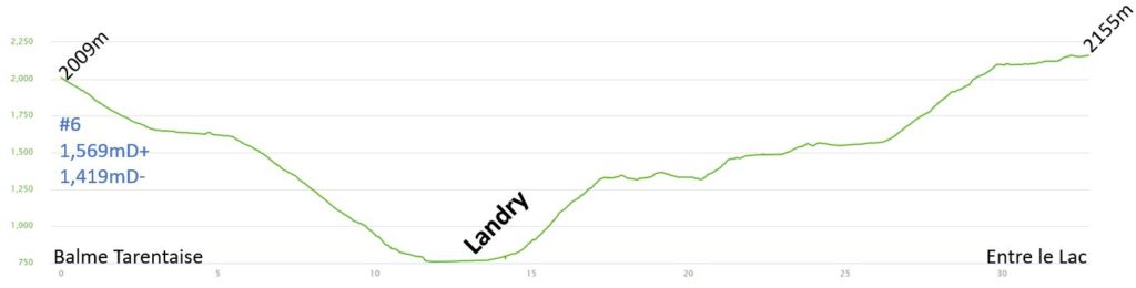
There are other advantages to starting early, for example, you see more wildlife. This morning I saw many marmottes, a couple of foxes and some bouquetins. It took me roughly 2 hours to reach the bottom of the Isère valley. This path passed through small villages, the of Valezan and Bellentre. In the past these villages were reliant on farming activities to survive, but now rely on hiking and other Summer leisure activities. The snow on their South facing slopes is not suitable for winter sports as all of the ski lifts are on the North facing slopes in La Plagne and Les Arcs, on the other side of the valley.
The GR5 followed the river on a cycle lane to reach the village Landry.
This village is a main point on the GR5. It has a train station, which enables many to finish or start the GR5, tackling it in a few stages at a time.
The start of the climb to Peisey-Nacroix was very steep, slow and hot, although it was cooler walking under the trees. When I arrived in the village, I admired the small streets and churches. La Plagne is a big ski resort for winter sports, it has lots of ski lifts which give plenty of access to the mountains. Just before Les Lanches, I stopped to enjoy my picnic in the shadow of some big pine trees. The temperature was reaching nearly 34°C. The climb in this valley was very gradual, until I reached the refuge, “the Rosuel”, afterwards there was a steep 500m climb, which was difficult in the heat. Each tree was a great place for a quick break. I ate a lot of raspberries and currants. I spotted some clever kids, exchanging fruits for sweets.
After Pertes du Pouturin, I left the GR5, and went left and further on took a path to the right to reach the Refuge d’Entre le Lac (2,155m). This magnificent lac was busy, with lots of hikers and fishermen. I really enjoyed today’s hike, especially the path from refuge Rosuel. The hike finished in the early afternoon and many hikers were enjoying a nice lunch. I treated myself with a tarte aux Myrtilles (blue berries) and a local beer. I skipped the shower today and just washed my clothes. Before dinner, I had the chance to observe some wildlife, there were a few Bouquetins and marmottes nearby the refuge.
Unfortunately, having to Book your accommodation in the refuges weeks before you start the GR5, does not allow for any flexibility. I would have preferred hiking for a few hours more each day, hiking perhaps an additional 10 to 15km, but I would have needed to carry a tent, and I opted to carry a lighter bag instead.
The dinner with the other hikers was great and we had a great discussion about our equipment and shared some tips. I was in bed early at 9pm, looking forward to the next day’s hike.
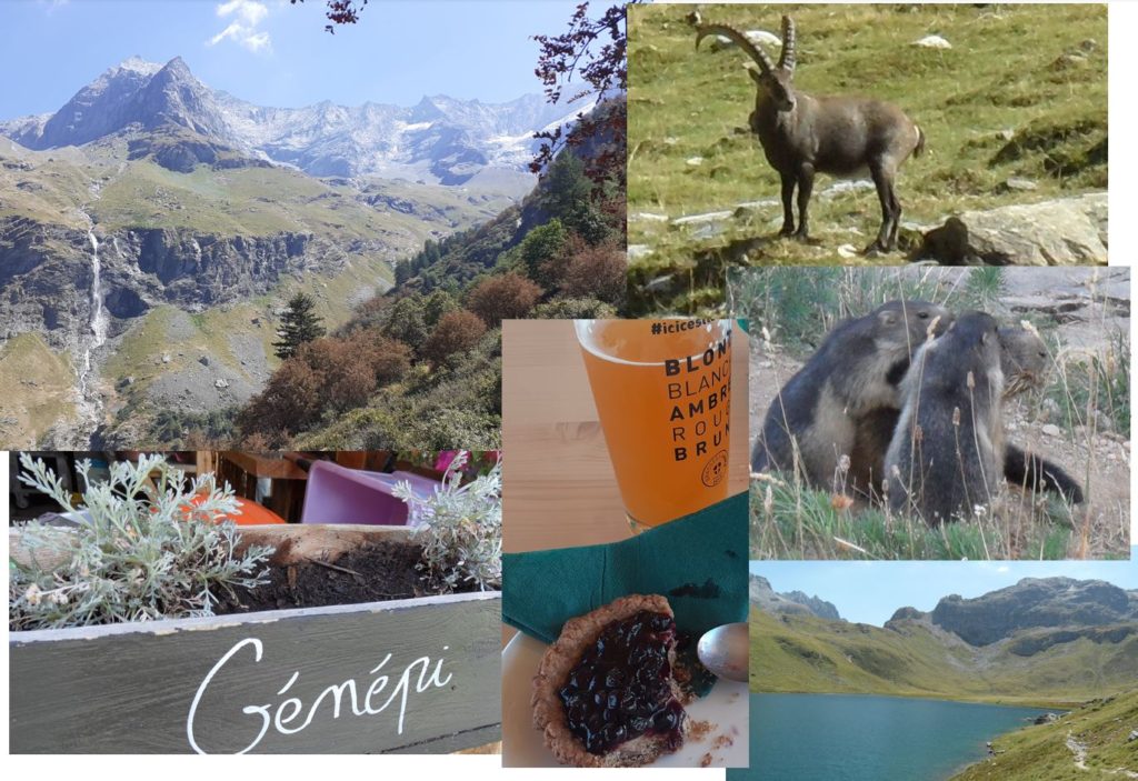
Pictures of the day:
Day 7 – Refuge du Col de la Vanoise : 29.7km 1596mD+
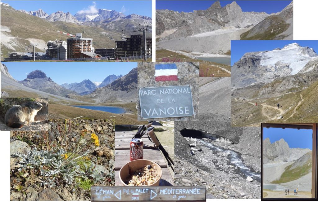
I was really looking forward to the following few days, the GR5 and the GR55 pass through the “Parc de La Vanoise”. This national park is situated at high altitude and is famous for its wildlife. After the 6.30 a.m. breakfast I was ready for a long day’s hike.
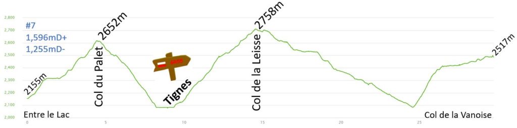
The day started with a short steep 500m climb from the refuge to return to the GR5 path. At this time, I was alone on the path, stopping a couple of times to take pictures of the picturesque mountains. The morning sun was painting the summits in orange / pink. I passed at the Refuge du Palet, but It was closed all summer because of the water drought. At the refuge, there was a sign: “Leman 12 jours – Méditerranée 23 jours”. Although the refuge was closed, there were a few hikers putting up their tents nearby on the grass. I reached the Col du Palet (2,652m) in roughly 1 hour. The view was great on all the summits, but I could not see Tignes yet. La Grande Motte (3,653m) was in the clouds.
On the descent to Tignes, I spotted a lot of Marmottes enjoying the morning sun. The GR5 takes a singletrack past the ski slopes. The sight of the pillars of the ski lifts are horrible in comparison to the scenery I have seen so far on this trip. At this point I could see the Lake in Tignes, and in the shadow of the mountain, I could see the village of Val Claret. Just before the lake, I left the GR5 and went left to follow the GR55, hiking through the Val Claret. This village was busy even in summer as the glacier is open all year round for skiing. The village has nice buildings with painted shutters and a has a lovely view of the mountains, but unfortunately the view is now obstructed by the Ski resort, with its big concrete constructions. I was astonished and disappointed to see so many ski lifts and concrete buildings. I stopped quickly for a “Pain aux raisins” in the local boulangerie and continued my hike to climb higher in direction of the Parc de la Vanoise (In 1963 it became the first national park in France).
The GR55 was very quiet, I saw a couple of Marmottes and was able to admire the glaciers on the Grande Motte and later I climbed under the ski lift in the Vallon du Pâquis. Before the Col de Fresse, I turned right and entered the Parc de la Vanoise. The final climb to the col de La Leisse (2,758m) was quick, it took me 1h20 to climb the 750 meters.
Afterwards, I started a long descent to the Leisse Valley. The river was coming from the Glaciers, and the slopes were full of stones, is in fact, the glacier itself. I stopped at the Refuge de la Leisse (2,460m) for lunch. I bought a local coke (Yaute Cola) and had my picnic. There was a chicken there who was interested in my lunch, which enjoyed my crumbs. It was more than 30°C and the coke was perfect for quenching my thirst.
I was fascinated by the Torrent de la Leisse, with its powerful waters. Some snow tunnels were carved by the river at the bottom of the Glaciers. The descent finished at the bridge, from where I could see the Refuge d’Entre Deux Eaux. I then left the valley to climb to the Ruisseau de la Vanoise Valley.
The short climb was steep, and it took me roughly 30 minutes to climb the 300 meters. There were many vestiges from the war. Once I reached the valley, it was an easy hike to reach the Refuge du Col de la Vanoise (2,518m), which was just under the summit/Glacier of the Grande Casse (3,855m).
I arrived very early at around 1.30pm, which gave me plenty of time to enjoy a 3-minute hot shower and clean my clothes before enjoying a relaxing afternoon in the refuge. My body was starting to acclimatise to the altitude and the long daily hikes. I could have hiked another 3 to 4 hours and reached the refuge du Roc de la Pêche or the Refuge Péclet Polset, but as I mentioned earlier, booking the refuges weeks before the start of the hike did not allow any flexibility.
I was hoping to see lots of wild animals on today’s hike, but I was not lucky. I saw few marmottes, but most of them were outside of the Parc de la Vanoise. At dinner I had another great discussion with fellow hikers. Most of them were just there for the weekend in the mountains, spending the Saturday night in the refuge, escaping the heat of the Summer sun.
The view from the bedroom, of the Glacier of the Grande Casse, was fantastic.
Pictures of the day:
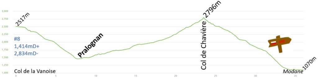
Day 8 – Modane : 36km 1414mD+
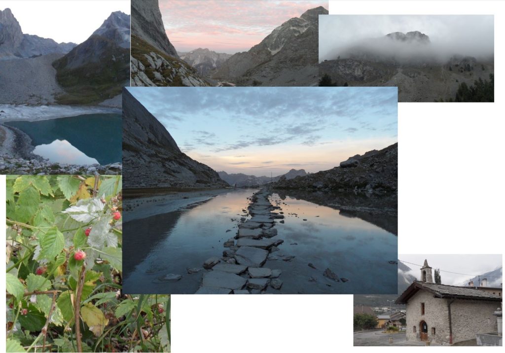
Today’s hike should be long and at high altitude. I was looking forward to the start of this hike as it crosses the Lac des Vaches. There are big stones making a bridge across this famous high-altitude lake. Also from Pralognan, there is the climb to the highest col, on the GR5 : Col de Chavière (2,796m), and afterwards follows a long descent to Modane (1,070m).
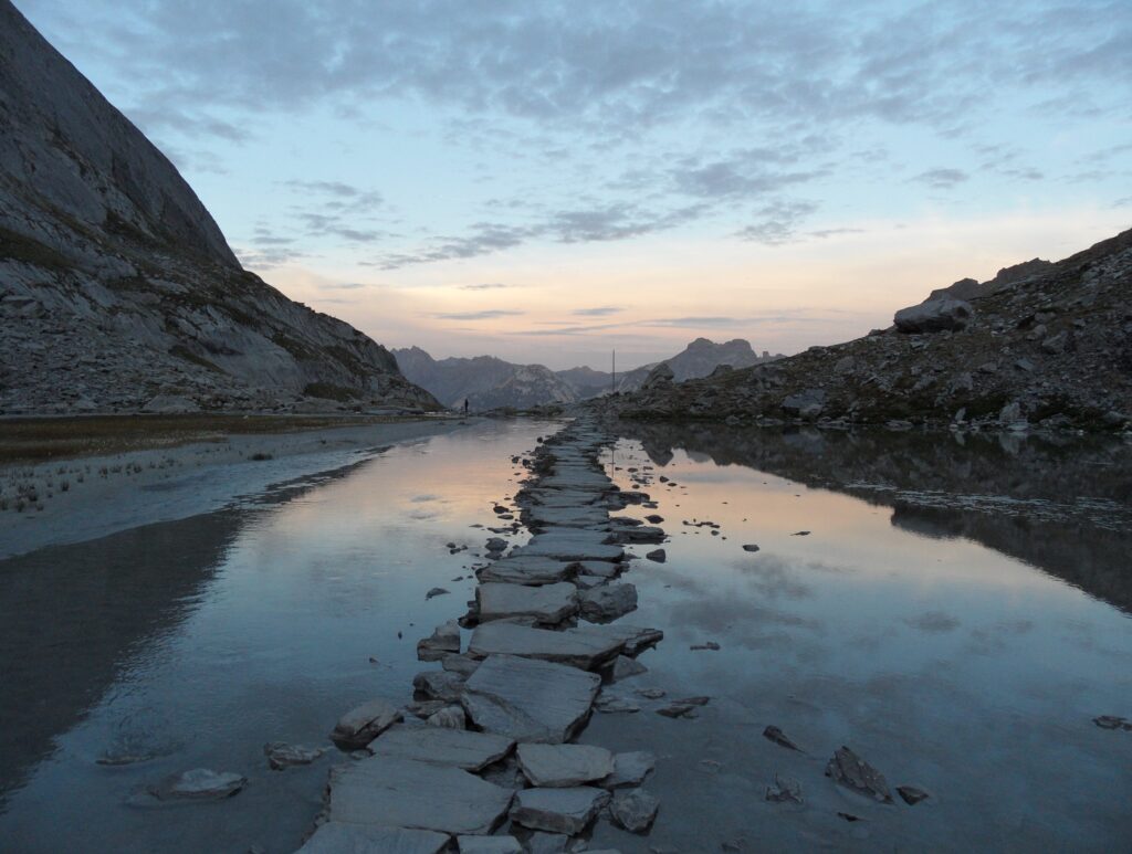
The forecast for the afternoon was not great with a storm due from 2pm onwards. I started early to try to cross the high-altitude col before the storm. Lightning strikes in the mountains are very dangerous. Luckily, I had breakfast, early at 6am and enjoyed the start of the descent before sunrise. The mountain reflections in the lakes were just magical. The sky was orange and the clouds made the views unreal!
I reached the Lac des vaches (2,330m) and was lucky to see this:
After a last look at the Grande Casse and I continued the descent to Pralognan (1,450m). I arrived quickly to the village at 7.30, and started the long climb to Col de Chavière (2,796m). It was not easy to find the correct path, and I had to use my map / book a few times.
I then started a long climb in the Doron de Chavière valley. It is not steep, but it is a long 16km hike for the 1,350m climb. A few electric mountain bikes overtook me. I stopped at the Refuge du Roc de la Pêche (1,950m) at 9am to fill-up my water bottle, but I did not stop long and continued the climb. The sky was now cloudy, and the rain was about to start soon. I had more than 15km done when it started raining at 10 am, I still had 4km with 500m climb to reach the summit. I then started to feel pain on my right shin. The pain increased, so I started to slow down. It was still a long way to reach Modane: 4km uphill and then 13km downhill.
During the following 4 hours, the pain increased, and I was not in a good mood. The rain got heavier and I was in the clouds, reducing the visibility. I missed the path a few times, because some hikers created many cairns on the side of the path, which made the navigation trickier. The last part of the climb was very steep, and I was delighted to reach the Col de Chavière (2,796m). Unfortunately, there was no view because I was in the clouds. This part of the path was busy.
I started the descent and the pain increased. I was very slow and every time my right foot touched a stone, the pain was acute. At 11am, I had a break to enjoy my sandwich. I did not stop long because I knew the rest of the day would be long. Each time I was lifting my toes, the pain was increasing. The pain was so bad at one point, I thought I might have a stress fracture. My quad pain from the first days was gone, but maybe by my body compensating for my quad pain and my weight plus the bag weight may have stressed the shin muscle or bone? I continued my descent to Modane. I was thinking, it may be my last hiking day on the GR5. From Modane, there are trains, and I would be able to reach my family in Lyon, if I needed to leave. I stopped a few times to pick and eat some Raspberries.
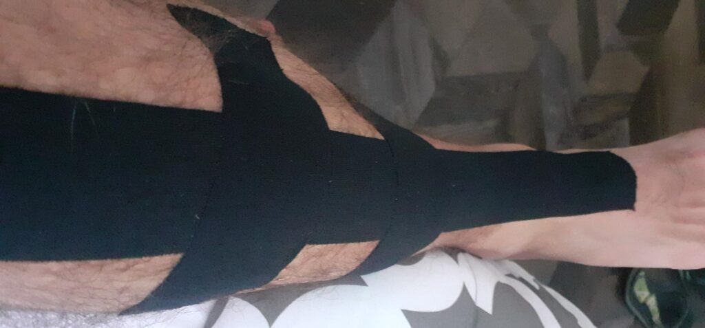
I finally reached Modane at 2pm. Finally, even with the injury, the day’s hike was short. I went straight to the Pharmacy. It was closed on Sunday afternoon, but there was one open close to my hotel in Fourneaux. I bought some anti-inflammatory cream (Arnica) and KT tape. I forgot that I did not have scissors, but was able to buy a knife from a nearby souvenir shop. After showering in the hotel, I put a lot of cream on my shin and applied KT tape. I was hoping for a shin splint, not a stress fracture. Both my shin and ankle were inflamed.
Later that evening, I had a pizza and went to bed early, hoping I’d be able to hike the next day!
Pictures of the day:
———– TO BE CONTINUED ———–