In this fifth and final part of the GR5 hike, I walked from Rimplas to Menton over GR5 stages 16 to 18.
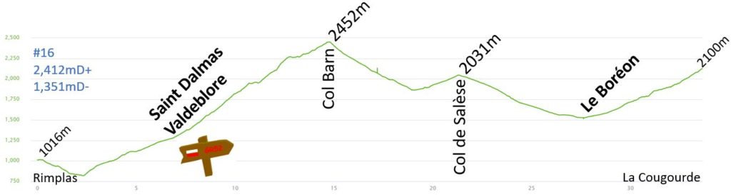
Day 16 – Refuge de la Cougourde : 33.7km 2412mD+
After two very long hiking days, Day 16 was shorter and brought me to Parc du Mercantour. This variant of the GR5 is named GR52 and is one of the highlights of this hike. You can view my route on this link:
With the shorter hike, I enjoyed breakfast in the hotel and started just after 8 am. The hike started with a short descent to the valley and a long climb of 1,600 meters in altitude gain. Most of the climb to Saint Dalmas was on the road or on large gravel roads. The temperature was cool (~25⁰C) and I was in the woods. When I arrived in La Bolline, I thought I was in Saint Dalmas. It was just 9 am. I checked the map in the guide and understood that Saint Dalmas was roughly 2 km further and 150 m higher.
I arrived in Saint Dalmas, and I was very careful. The GR5 goes south to Nice, and I need to turn left to the North to enter the Parc du Mercantour. There are some road works close to the river, and I think the signs were removed. I decided to follow the map and followed the road climbing on the right side of the river and started to find some red/white signs again.
After less than 800 m, the road ended, and I continued on the singletrack. It started to get hot, and I still had to climb 1000 m in altitude gain. I only overtook a couple of hikers during the next part of the climb. It was very quiet and enjoyable.
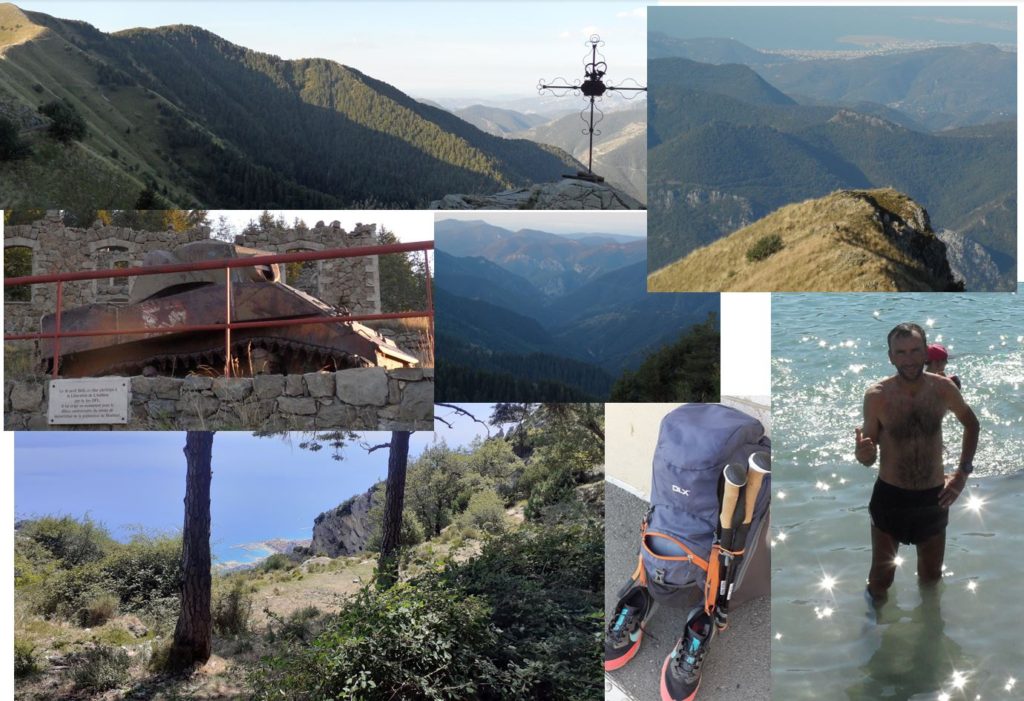
At 10:30 am, I reached Vallon de Bramafan. The road leads to this point, and groups of hikers were enjoying the view and the lovely paths. I saw a few sheep herds and was always cautious to avoid them or be close to the dogs. I am always happy to see the shepherd because the dogs stay quiet with the shepherd. On the final climb, two young hikers accelerated when I passed them. I had to push to arrive at the summit before them. It was tough with a 10 kg backpack, but I enjoyed the challenge. You can follow the climb with Google Maps/Street View using this link:
The view from the Col du Barn was great. I arrived there just at 12 pm. I had hiked just 15 km and reached a little less than halfway but managed most of the climb. I enjoyed a quick cereal bar during a very short stop before rushing downhill. It was a lovely singletrack along the river. The descent to Vallon des Mollières was only 45 minutes, and I descended roughly 600 m in altitude. I had no sandwich that day and planned to get food in Le Boréon.
Instead of climbing on the dirt road, I had the “good idea” to take a cow path close to the river. I ended up in deep “mud” and climbed the riverbank among thorns. I reached Col de Salèse and started the descent to Le Boréon, but some parts of the GR52 have been closed for the last 2 years.
On 2-3 October 2020, the Alex storm hit the southeast of France, with the Vésubie Valley being badly affected. Two years later, the damage was still visible, and a part of the GR5 leading to Le Boréon was still closed. The path had been replaced by roughly 3km of road. You can see the damage in this video from the local television:
I finally reached Le Boréon at 2:30 pm. The local restaurant had finished serving lunch, so I asked if they could prepare a quick ham sandwich. They agreed but discovered they had no bread left. Instead, they offered to prepare a burger to go, which I agreed to and really enjoyed during my 30-minute break. I added a coke and chips to the burger, which was a nice surprise.
The climb to the Cougourde refuge (2,100m) was slow after my big lunch. The valley had been destroyed during the Alex storm, and although the road had been rebuilt, the GR path had not. The climb started on the road, and after 30 minutes, I reached the path for the last climb of the day. The forest and path were not impacted by the Storm Alex. The last 400m climb was completed in nearly one hour. The refuge had been added to the GR52 only recently and was not in the older guides. It was very remote, and the other refuges (Madone de Fenestre, Nice, Merveilles) were completely booked months in advance. I reached the refuge around 4:30 pm.
I enjoyed a nice hot shower, cleaned my clothes, and had a beer before the 7 pm dinner. I went to bed early with my backpack ready for the next day.
Pictures of the day:
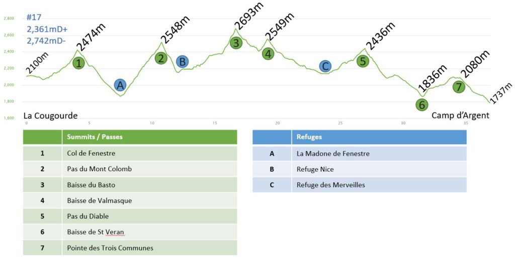
Day 17 – Camp d’Argent : 36.9km 2361mD+
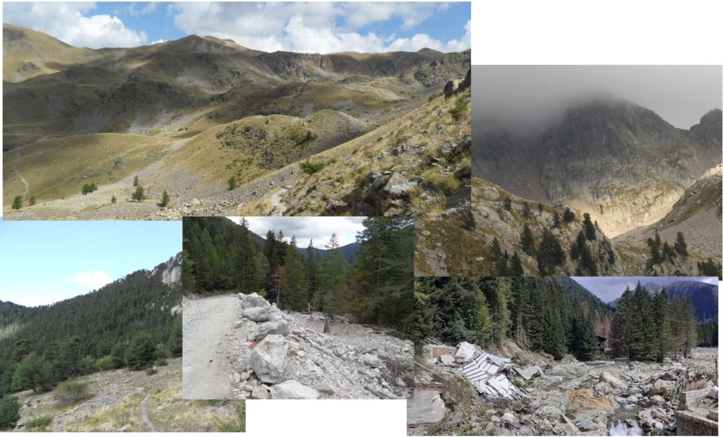
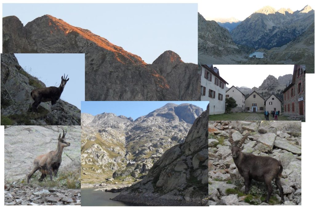
All the refuges in this part of the hike were fully booked, so I decided to push on and reach Camp d’Argent. It was a physically demanding hike covering over 40 kilometers. Despite the challenge, this stage turned out to be the best one, with the mountains appearing so steep yet so beautiful. I had the privilege of seeing hundreds of animals throughout the day, starting with an early start to catch a glimpse of the sunrise and many Chamois. Later on, I encountered a Bouquetin on the steep climb to Pas du Mont Colomb, and a few more enjoying the sun at the top of Baisse du Basto. The highlight of the stage was crossing the Vallée des Merveilles, where our pre-historic cousins left us with their stone engravings!
Moving at a slow pace, this long stage felt never-ending. The terrain was incredibly technical, and each climb was steep and challenging. However, reaching the top of Pas du Diable was a moment to cherish as I caught my first glimpse of the sea, with Nice and its airport recognizable despite being more than 30 kilometers away. The finish line was now within reach!
I woke up at 5:30 am and enjoyed an early breakfast at the refuge. They had left food on the table and coffee in a thermos the previous evening, so I was able to have breakfast and leave promptly at 6 am. However, I made a mistake in the dark and lost 10 minutes at the start.
It took me another hour to reach the summit of the Col de Fenestre, which is less than one kilometer from the Italian border. At the summit, there were 4 or 5 Chamois, and I spent some time taking pictures and short videos of them. Since it was still dark, I wanted to make sure that the pictures would come out nicely. Since there was no one on the mountain so early in the morning, I had the place all to myself.
On the other side of the mountain, there were dozens of Chamois, and as I began to descend towards the Refuge de Fenestre, I started to meet other hikers. The refuge can be reached by car, which makes it a popular destination. The refuges are quite large, and I saw groups of hikers enjoying their breakfast or starting their daily walk. It was around 8 am.
The second climb was tough, with “only” 600m of altitude gain, but it was very steep. At this altitude, the area was only mineral, and I had to be careful to keep track of the path. It was a beautiful sunny day, but it must be tough on a foggy day. On the middle of the climb, I saw a big bouquetin just a few meters from the path. The start of the day was great with all these wild animals. The final ramp of the climb was very steep, and I was happy to have my hiking poles. A lady pushed hard to reach the summit before me, and she won. I reached the Pas du Mont Colomb (2,548m) at 9 am, and the temperature was already 25⁰C. I had covered just 10km and 1000 meters of altitude gain.
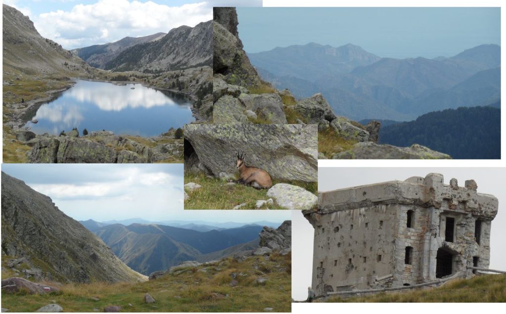
The descent to the Lac de la Fous was also very steep, and it took only 30 minutes to reach the bottom of the valley. I went around the lake to arrive at the Refuge Nice, where I stopped for 15 minutes to have a sandwich and refill my water bottles. A few chickens were interested in the crumbs of my sandwich. A group of French army men was starting their hike with very big and heavy backpacks. I did not envy them.
I took many pictures and would like to share them with you.
The climb to Baisse de Basto (2,693m) started in a green valley. I could see many hikers on this route. Then the trail became more rocky and technical. The final ascent was again very steep.
The next section involved a short descent to Lac du Basto, followed by a climb to Baisse de Valmasque (2,549m). It was only 2 kilometers, but it took me 40 minutes to cover. In 6 hours, I had only covered 18 kilometers. I was worried about the remaining 21 kilometers. At this pace, I would need another 7 hours! And I felt like I was pushing myself.
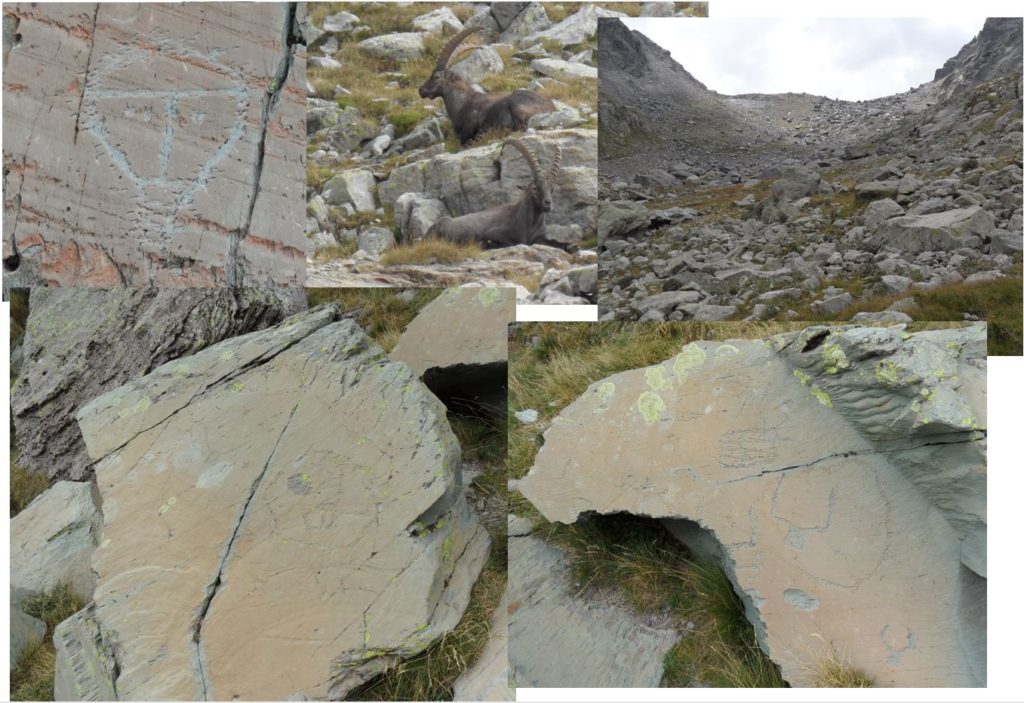
I was looking forward to spending some time in the next valley, the Vallée des Merveilles. The Mercantour contains almost 40,000 prehistoric rock engravings spread over 15 km² around Mont-Bego. This group of Bronze Age engravings is listed as a historic monument. Welcome to the Vallée des Merveilles, 2,300 meters above sea level (“Valleys of Wonders and Fontanalba” in English)!
It was great to see these engraved rocks in person. I had seen them in my school books when I was a kid and had been looking forward to this moment. In this part of the hike, it is forbidden to use poles, so I had to hang them from my backpack.
This valley was very busy with many tourists. Unfortunately, some of them were engraving their names on the stones close to the prehistoric art! Mass tourism is always a problem.
I enjoyed a local Coke at the Refuge des Merveilles. It was roughly 1:30 pm and I was ready for the final part of this epic day.
The trail was so beautiful that I had to share more pictures. In the Vallée des Merveilles, there are inscriptions from thousands of years ago:
For the remaining 14km of the day, I needed to keep going and avoid stopping too much to take pictures. But it was so beautiful that it was difficult. I will have to come back to the area and split this into 2 or 3 days.
The climb to the Pas du diable starts in a large green valley in the middle of many lakes (Fourca and Muta). It was very quiet and getting cooler too. The end of the climb was steep, but from the top, I was surprised to see the Mediterranean Sea for the first time. I could feel the end of the trip! It was a mix of feelings between the happiness to finish and the sadness to stop this hike.
The start of the descent was steep among the stones, and then I arrived in the grassland. Another group of Chamoix was enjoying the fresh grass, and I could see a big sheep herd. I was lucky not to meet any of the Pyrenean Mountain Dogs. The rest of the hike was in a slight descent on the side of the mountains. There were many forts from the different wars between France and Italy. Between Baisse de Saint-Véran and La Redoute, there was a final climb of 150 meters. After nearly 10 hours of hiking, it was difficult to stay motivated to push through this last climb.
Finally, I reached the Refuge de Camp d’Argent just before 5pm. It was a big refuge and was very busy. A few beers to celebrate the last evening of this adventure before the shower. I decided not to wash the clothes for the last day. Going down to sea level would be very hot the following day! The early dinner was great to refuel, and I was in bed early.
And the final pictures of day 17:
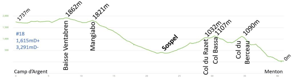
Day 18 – Menton : 41km 1615mD+
The last day of the hike was going to be long, but mostly downhill. Despite having to cover over 40 km, I was eagerly looking forward to a swim in the sea!
The start of the final stage didn’t go smoothly. The refuge owner asked me to store my shoes in a locked shed, and I was unable to retrieve them for nearly an hour. Despite the delay, I remained determined to enjoy the last hiking day. The weather was cool, and I started with my jacket on, but after 20 minutes, I was comfortable in just a long-sleeved t-shirt. I encountered a few deer in the forest and the sun was already shining bright over the Italian mountains. The trail ran parallel to the road I had taken the previous night to reach the refuge.
After an hour, I reached the local road in Moulinet, which had old barracks and an old tank. At 8am, I reached the summit of Baisse Ventrabren (1,862m), which was the highest summit of the day. The view from this point was great, and the villages in the valleys seemed so far away! There was just one more climb to Mangiabo (1,821m) before the long descent to Sospel.
The route was very quiet. I overtook two hikers, two cows, and a shepherd with his dogs. The path dropped by nearly 1,500m in altitude, which was tough on my quads, and the temperature gradually increased. By 10:30am, I had reached Sospel, where the temperature was above 30⁰C. The village was busy with tourists and locals. I enjoyed a nice coffee and pain aux raisins on the terrace just after the Bévéra river. It took me roughly four hours to complete these first 21 kilometers of the day.
After stopping for roughly 15 minutes to enjoy my coffee, I started to follow the red and white signs. Unfortunately, it was a local GR trail and not the GR52. It brought me close to the graveyard and in the west direction. The GR52 trail actually leaves to the east in the direction of the train station, and I lost another 15 minutes due to this mistake and an extra kilometer.
The sun was beating down, and there was not a lot of shelter on the road. Close to the swimming pool, the GR52 trail began to climb steeply in the forest. I let a few motocross riders pass by, and it was quiet again. The locals were at the pool and not hiking.
It was a steep climb of roughly 700m to reach the Col du Razet (1,032m). The climb was not finished, and another 100m above, very close to the Italian border, I reached the Col Bassa (1,107m). The hike was mainly in the forest, and it was not so easy to understand where the next summit or the sea was. It was roughly 1pm, and I had covered roughly 30km.
The path was now descending, but after losing 200m of altitude, it was time for the final climb of the day on the GR5 – a 300m ascent to the Col du Berceau. It was challenging in the heat, but it felt great to reach this point. The area was busy, and I met people starting the GR5 or people enjoying the view.
I sat down to enjoy my last sandwich in the shade of pine trees, with Monaco/Menton at my feet. I took a 20-minute break and had mixed emotions about this adventure.
The last descent was tough on my quads with a 1,100m drop. The path was slippery, and I had to be careful. The view was breathtaking, but in the last area, there were many clothes from migrants who were moving from Italy to France through this area. They were afraid to meet Gendarmes on the main roads/train stations, so they hid in the forest.
The last 500m of altitude loss was on the road, passing between motorways, bridges, and billionaire houses. Sometimes it was tricky to see the path amidst these houses. Finally, I reached the promenade and had to walk another 800m to put my feet on the beach and in the sea.
I removed my shoes and T-shirt to enjoy a bath in “La Grande Bleue.” I thought about the end of this 18-day journey covering 607km, 143 hours, and 34,761m of ascent (and many beers). These numbers were just numbers, but the emotions I felt in that moment will stay with me forever.
Many days, I had no phone coverage, or I had to put the phone in airplane mode to save the battery. It was great to disconnect and reconnect with the present.
If you’ve taken the time to read all these articles, I suggest you consider undertaking this journey. It was a fantastic holiday for me, and I will remember it forever.
Pictures of the day: