Corsica’s GR20, often hailed as Europe’s toughest long-distance trail, is a formidable beast. Traversing the island’s mountainous spine, it typically takes experienced hikers around 15 days to complete. But in June 2025, I set out to tame this beast in a mere five days – an audacious challenge that pushed me to my absolute limits and delivered an unforgettable adventure.
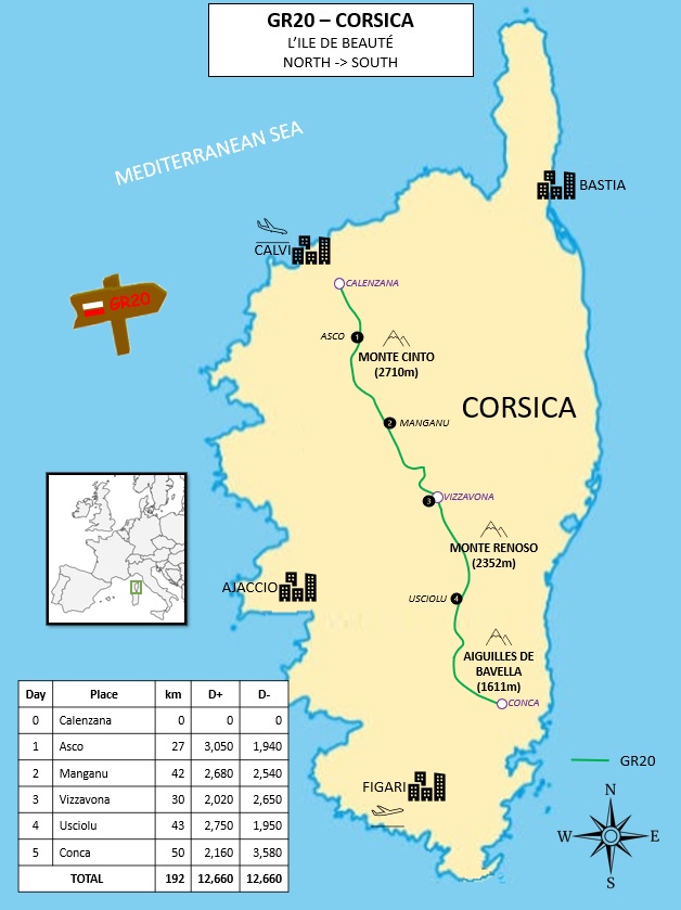
The GR20, stretching approximately 180 kilometers from Calenzana in the north to Conca in the south, is renowned for its rugged terrain, steep ascents and descents, and breathtaking panoramic views. It’s a true test of endurance, mental fortitude, and mountain skills. My goal was not just to finish, but to experience the essence of this legendary trail in a concentrated burst of high-intensity trekking.
Here’s a breakdown of my whirlwind journey across Corsica:
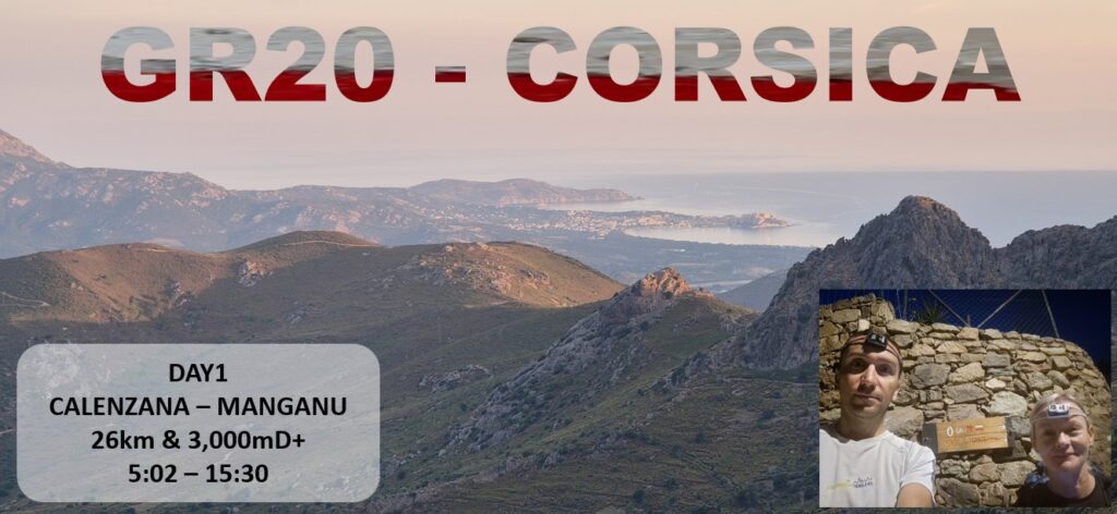
Day 1: Calenzana to Asco – A Baptism by Fire
- Distance: 26.7 km
- Elevation Gain (D+): 3,050m
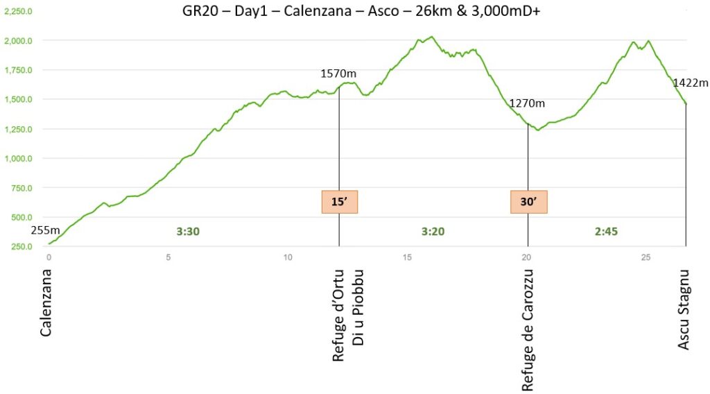
The first day was a brutal introduction to the GR20’s notoriously challenging northern section. Kicking off from Calenzana, the trail immediately plunged into steep, rocky climbs. Every step demanded focus, navigating a labyrinth of boulders and exposed ridges. The relentless 3,000 meters of ascent tested my legs and resolve from the outset. Reaching Asco after hours of relentless climbing and technical scrambling, I felt the satisfying ache of a day truly earned, already understanding the magnitude of the challenge ahead.
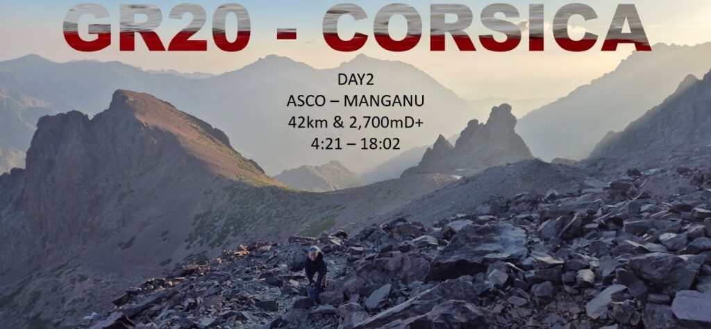
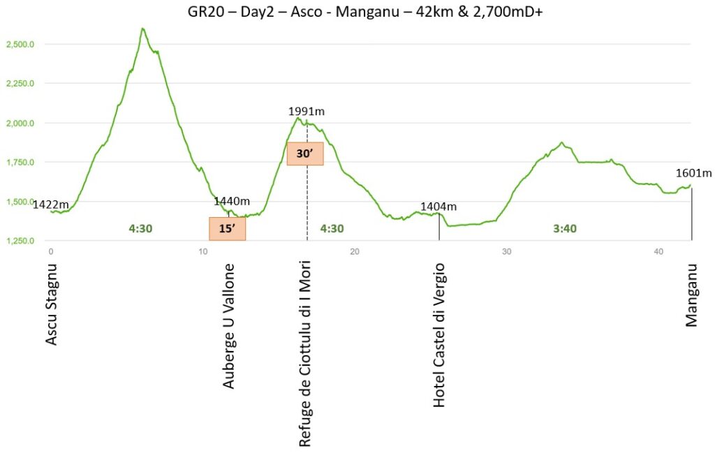
Day 2: Asco to Manganu – The Heart of the High Mountains
- Distance: 42 km
- Elevation Gain (D+): 2,680m
If Day 1 was tough, Day 2 was an epic. Covering an incredible 42 kilometers, this was one of the longest and most demanding stretches. Leaving Asco, the route led me into the majestic high mountains, offering some of the GR20’s most iconic landscapes. I traversed stunning cirques, crossed high mountain passes, and navigated snow patches even in early summer. The views were immense, but so was the effort. The cumulative 2,680 meters of ascent felt relentless, but the sheer beauty of the Corsican wilderness, coupled with the immense satisfaction of covering such ground, propelled me towards Manganu as dusk settled.
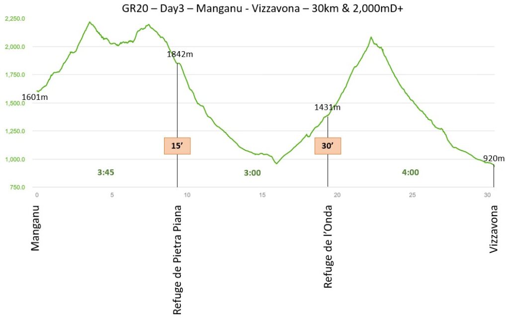
Day 3: Manganu to Vizzavona – Crossing the Divide
- Distance: 30 km
- Elevation Gain (D+): 2,020m
Day 3 offered a slight, though relative, reprieve in terms of overall distance, but certainly not in challenge. The 30 kilometers to Vizzavona, often considered the midpoint of the GR20, still packed a punch with 2,020 meters of ascent. This section saw me traverse the stunning glacial lakes, including Lac de Nino with its famous wild horses, before descending through ancient forests. Reaching Vizzavona, a small village with road access and a train station, felt like crossing a significant psychological threshold – the “official” halfway point, and a moment to briefly resupply and refocus before tackling the southern stages.
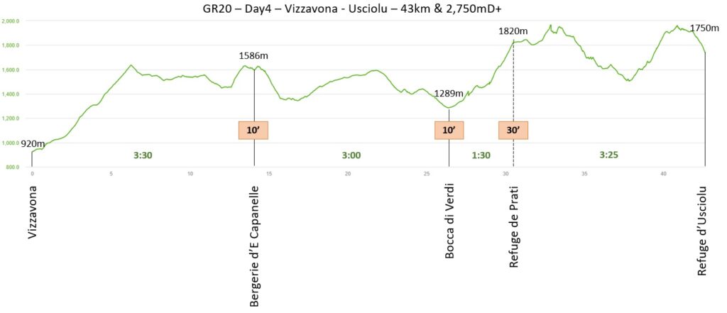
Day 4: Vizzavona to Usciolu – The Southern Grind Begins
- Distance: 43 km
- Elevation Gain (D+): 2,750m
Refreshed, but with legs protesting, Day 4 ushered in the start of the GR20’s southern section. While generally considered less technically demanding than the north, the south compensates with long, undulating ridges and significant elevation changes. Covering 43 kilometers with 2,750 meters of ascent, this day was a testament to sustained endurance. The landscapes transitioned to more open, sweeping vistas, but the relentless up and down kept the pressure on. Arriving at Usciolu, high on a ridge, was a welcome sight, signaling that the finish line, though still distant, was within reach.
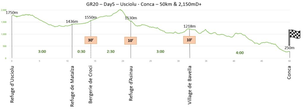
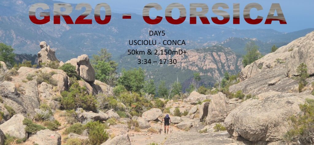
Day 5: Usciolu to Conca – The Final, Heroic Push
- Distance: 50 km
- Elevation Gain (D+): 2,160m
The final day was monumental. With 50 kilometers to cover and 2,160 meters of ascent still to conquer, it was a test of sheer willpower. Every muscle screamed, but the thought of reaching Conca, the official southern terminus, fueled my stride. The trail meandered through captivating maquis, past remote shepherds’ huts, and over a final series of passes. The mental game was as crucial as the physical one. As Conca slowly appeared in the distance, a wave of immense relief and exhilaration washed over me. Stepping into the village square, after five days of relentless effort, felt like crossing the finish line of the ultimate ultra-trail.
Packing Light : My hiking essentials
As an experienced day hiker, I prefer to keep my pack light and move comfortably and quickly. For daily hikes, I typically use a 5-10 liter backpack, carrying safety gear, water, food, camera, drone, and jackets, usually weighing around 4 kg. For the GR5, I aimed to keep my 40-liter backpack under 6 kg. I didn’t bring hiking poles for this technical hike, which will require me to use my hands to scramble.
| ITEM | Weight [g] | Quantity | Total weight [g] |
| short | 110 | 1 | 110 |
| tshirt | 110 | 1 | 110 |
| cap | 50 | 1 | 50 |
| Sunglasses category 4 | 30 | 1 | 30 |
| Socks | 40 | 1 | 40 |
| Underwear | 40 | 1 | 40 |
| Trail running shoes (Hoka Speedgoat 6) | 580 | 1 | 580 |
Hiking Clothes
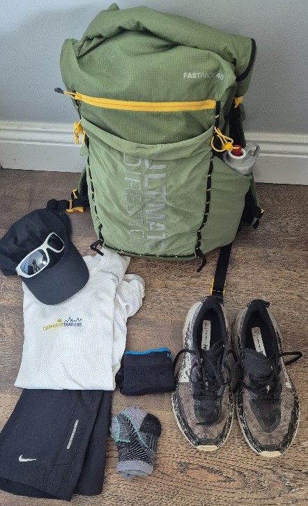
The backpack : Minimalist Approach
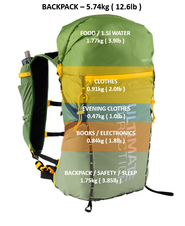
My plan was to sleep in refuges and hotels along the way, relying on them for dinner and breakfast. I packed only snacks and picnics for daytime sustenance. A sleeping bag was necessary in the refuges, because they did not provide blankets. For emergencies, I carried a safety blanket. My 40-liter backpack proved ample, and I successfully kept its weight under 6 kilograms.
Backpack / safety / sleep – 1.75kg
| ITEM | Weight [g] | Quantity | Total weight [g] |
| Backpack (Ultimate Direction Fastpack 40l) | 709 | 1 | 709 |
| Sleeping bag (Kamperbox UL250) | 500 | 1 | 500 |
| Dry bag XL green (Exped) | 80 | 1 | 80 |
| Safety blanket + toilet paper | 60 | 1 | 60 |
| Headlamp (Petzl) | 30 | 1 | 30 |
| soap, tooth brush, creams thread/needles, KT tape… | 180 | 1 | 180 |
| 1/4 microfibre towel (decathlon) | 50 | 1 | 50 |
| passport + credit cards + cash (ensure you bring cash, only few places accept card payment) | 140 | 1 | 140 |
Backpack / safety / sleep
Clothes – 0.9kg
| ITEM | Weight [g] | Quantity | Total weight [g] |
| Gore tex jacket (Cimalp) | 230 | 1 | 230 |
| Down jacket | 310 | 1 | 310 |
| Long sleeve t-shirt (Millet) | 200 | 1 | 200 |
| Gloves (Lowe Alpine) | 40 | 1 | 40 |
| Socks (spare) | 40 | 2 | 80 |
| Underwear (spare) | 30 | 2 | 60 |
| Swim suite | 60 | 1 | 60 |
Clothes
Evening Clothes – 0.47kg
| ITEM | Weight [g] | Quantity | Weight [g] |
| 1st layer long sleeves (HH) | 130 | 1 | 130 |
| Trousers (Nike) | 170 | 1 | 170 |
| Underwear (NB) | 50 | 1 | 50 |
| Toe socks (Aonijie) | 40 | 1 | 40 |
| EVA foldable slippers | 80 | 1 | 80 |
Evening clothes
Food / water – 1.77kg
| ITEM | Weight [g] | Quantity | Total weight [g] |
| bottles | 110 | 1 | 110 |
| electrolites (x5) | 30 | 1 | 30 |
| water | 1500 | 1 | 1500 |
| cereal bars / gels | 130 | 1 | 130 |
Food
Electronics – 0.84kg
| ITEM | Total weight [g] | Quantity | Total weight [g] |
| Power bank 10,000mAh INIU + cables + USB plug | 160 + 30 + 50 | 1 | 240 |
| insta 360 X5 + stick | 230 + 120 | 1 | 350 |
| Samsubg Earbuds | 50 | 1 | 50 |
| Phone Samsung S24 | 200 | 1 | 200 |
Books / Electronics
In fact, my backpack typically weighed less than 6 kilograms (12.6lb). On days with poor weather, when I wore more layers, the pack’s weight would drop to roughly 5 kilograms (though I rarely needed long sleeves or jackets during this particular hike).
I carried no spare change of clothes, opting to hand-wash my dirty items with soap each evening. They dried quickly, ensuring I had clean, dry clothes most mornings. I only packed two extra pairs of underwear and two extra pairs of socks.
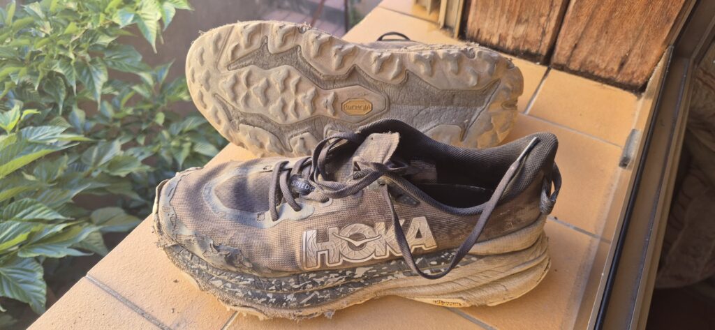
My body handled the hike very well. I only had one thorn in a finger and blisters on my feet. It was pure punishment for my feet. Every step was a gamble — either you’d stub your toes on jagged rocks, skid sideways on loose gravel, or smash the sides of your feet against sharp, unforgiving rocks or roots.
The shoes handled the trail, even though most of the grip was gone on the last days. The North part of the GR20 was very tough on the shoes.
Reflections on an Extraordinary Feat
Completing the GR20 in five days was not just a physical challenge; it was a profound mental exercise in perseverance. Every morning brought tired muscles, but also a renewed determination. The incredible beauty of Corsica, from its rugged peaks to its pristine natural pools, served as constant inspiration.
This extreme pace meant sacrificing some of the leisurely aspects of a multi-week hike – there was little time for long breaks, extended swims, or deep conversations. It was about relentless forward momentum. However, it offered a unique perspective on the trail, a condensed, high-intensity immersion into its raw power and beauty.
The GR20 is a truly special trail, and to have experienced it in such an expedited, yet deeply challenging, manner is something I will never forget. It proved that with rigorous training, meticulous planning, and an unshakeable will, even the “impossible” can become a reality on the trails.
The GR20: A Race Against Time
They call it the GR20, and for a reason—it’s the most difficult hike in Europe. While most people take 16 days to cross the island, we had just five. This wasn’t a hike; it was a race against the sun, the clock, and a mountain range that seemed determined to break us.
Day 1: A Grand Beginning
The GR20 is a legendary trail that carves its way through the heart of Corsica, a spine of jagged granite. For most, it’s a 16-day pilgrimage. For us, it was a five-day race against the sun, the clock, and our own physical limits.
We began our journey in Calenzana, setting off under the cover of headlamps at 5 a.m. The air was already warm, and the trail was a relentless climb from the very start. The northern section of the GR20 is a raw and rugged beast, with brutal terrain of slippery slabs and loose rocks demanding your full attention.
The first sunrise was a spectacle, painting the sky in fiery hues. We looked back to see Calvi and its bay, a stunning view that fueled our push upward. By 8:30 a.m., we were already at the first refuge, Ortu Di u Piobbu. We breezed through, pausing only to fill our water bottles before continuing the relentless climb.
After conquering the Bocca di Piccaia at 1950 meters, we reached the summit of our first day’s climb. The descent was a steep, technical scree path that required every ounce of focus. Just before lunch, we arrived at the busy Refuge de Carozzu. We indulged in two big pieces of chocolate cake and refilled our bottles—a small victory before pushing on. Our stop was brief—just 30 minutes—because we still had six kilometers to go.
The sun climbed higher, and with it, the heat intensified, reaching 34°C by midday. But the views were our constant companion and ultimate reward. Distant peaks and deep valleys kept us moving, one step at a time. This first day was a baptism by fire, a harsh but necessary introduction to what lay ahead. We finished at 3:30 p.m., leaving just enough time to shower, clean our clothes, and get an early dinner.
Day 2: The Physical Gauntlet
We started Day 2 long before the sun, waking up at 4 a.m. in Asco. We ate a massive breakfast at the refuge and stepped into the darkness. We had scouted the path the night before, but it was still a challenge to spot the white and red trail markers. For that first hour, the trail was a mystery, and we navigated almost entirely by instinct.
Today was the day we knew would truly test our limits. Our plan was to cover over 40 grueling kilometers with a staggering 2,700 meters of elevation gain. This wasn’t just a hike; it was a physical gauntlet. The trail became more technical with every step—scrambling over massive boulders and picking our way along treacherous ridges. My legs screamed and my lungs burned, but the rhythm of the trail took over.
Following a tragic accident in 2015 that closed the famous Cirque de la Solitude, the new route led us to a new challenge: climbing to Pointe des Eboulis at 2607 meters, near Monte Cinto, the highest mountain in Corsica. The first climb was brutally steep, and our progress was painfully slow. As we climbed above 2000 meters, we crossed patches of snow and the cold, biting wind forced us to put on our jackets. We reached the top just before 7 a.m. but didn’t stay long—the wind and cold were too intense, and we had no time to spare with 35 kilometers still on the map.
The long descent to the Tighjettu refuge took nearly two hours, but we were rewarded with a special sight: two mouflons at the beginning of the trail. We stopped for a much-needed coke and to fill up our water bottles. It was already sweltering, even at 9 a.m. Next came the second grueling ascent to over 2500 meters. The heat was relentless, and we were grateful for another stop at the Ciottulu di I Mori refuge to have our sandwiches and refuel.
The descent was technical at first, but soon we reached the bottom of the valley, where the trail became less steep. We entered a forest, and the blessed shade was a welcome relief. We passed Bergerie de Radule and Hôtel Castel di Vergio, feeling a small sense of victory, but a single question echoed in our minds: Would we make it to the refuge before they closed for the night? With a sudden burst of energy, we power-hiked the final climb, covering five kilometers in just one hour.
We reached Bocca a Reta at 1883 meters around 4:20 p.m. It was late, and we still had nine kilometers left. The final leg was a long walk, a seemingly endless zigzag through the valley. The views were breathtaking, with Lake Nino and a winding river below. We powered through, arriving at the Manganu refuge just after 6 p.m. We were ecstatic to learn that dinner was at 7 p.m., which gave us enough time for a hot shower before charging our electronics.
This second day was a long, hard struggle, but I was filled with pride for having made it through. The north of Corsica is unforgivingly technical, but with every step, the landscape revealed more of its wild, untamed beauty. Our feet and toes were starting to protest, but we had made it today. Conca was still 120 kilometers away, but we were one step closer.
Day 3: A Shift in the Landscape
After the grueling second day, we welcomed the slight shift in the trail’s character. Today’s path, while still challenging, felt a little more forgiving. Our goal was ambitious: to hike ‘only’ 30 kilometers from Manganu to Vizzavona. We began early, waking up at 4 a.m., and hit the trail at 4:40 a.m. Our warm-up was anything but gentle: a steep, 600-meter vertical climb to Bocca a e Porte at 2225 meters. The morning was cool and quiet, a stark contrast to the previous day’s intensity.
We saw a few patches of snow, even at the end of June, and reached the summit at 6 a.m. The view was absolutely fantastic. We had hiked just 3.5 kilometers, but the landscape was dramatic, and we could see the stunning Lac de Capitellu and Lac de Melu in the distance. We would continue above 2000 meters for another two hours. The terrain was incredibly technical, with chains to help us scramble over the rugged rocks.
Being alone on the trail so early was a joy, but our progress was slow—about 2.5 kilometers per hour. We reached our second summit of the day, Bocca Renosa, at 2150 meters, around 7:30 a.m. The one-hour descent to Refuge Pietra Piana wasn’t much quicker. We arrived at 8:15 a.m., having covered just nine kilometers in over four hours, and only stopped to fill up our water bottles.
We now had seven kilometers of downhill ahead. As we dropped into the valley, we were finally under the trees. The descent became much smoother and faster. This part of the trail was a stark contrast to the north; as we moved south, the mountains seemed to soften, trading their sharp, rocky edges for rounded, forested slopes. We passed many other hikers enjoying a dip in the river, but we had to push on. We covered this section in just two hours.
The final climb of the day was a 1200-meter ascent over six kilometers. We stopped at Refuge de l’Onda for a cool coke and our sandwiches around noon. By then, the temperature was soaring to over 30 degrees Celsius. The rest of the climb was a real struggle, but we finally reached Punta Muratello at 2141 meters around 1:30 p.m.
The descent to Vizzavona began slowly, but we found a second wind as the trail turned into a long path in the forest along the river. Our goal was to arrive early to clean up and charge all our electronics, anticipating the comfort of a hotel we had booked. We even had time for a celebratory bath in the river before finishing the hike. The air grew thick with the scent of pine and wildflowers as we reached Vizzavona, the official halfway point of the GR20. The hardest part of the journey was behind us, and a new, equally demanding challenge lay ahead.
Day 4: A Test of Endurance
The start of day four in Vizzavona marked a new chapter. The technical climbs of the north were replaced with long, continuous stretches that tested a different kind of strength: pure endurance. Today was all about covering distance—43 kilometers of it—with a significant amount of vertical gain. We set off well before dawn, just after 4 a.m., and made great progress in the woods, quickly climbing to the first summit. The path here was far less technical, and it took us just an hour and a half to cover the first six kilometers, climbing 700 meters.
The next 10 kilometers absolutely flew by. The trail was a smooth, single track through the forest with minimal climbing or descent. We passed many cows and met a few groups of hikers enjoying the early hours of the day. Our pace was fantastic, and we reached the Bergerie d’E Capanelle around 7:30 a.m., stopping only to refill our water bottles. The difference in pace between the North and the South of the GR20 was noticeable; we were now averaging roughly four kilometers per hour.
We continued our fast-paced hiking, hearing the unmistakable roar of French army fighter jets training over the Corsican mountains. The sound was incredible, but they moved too fast to capture on camera. The climb to the next refuge was tough, once again taking us above the treeline. The sun was intense, but the views were a great reward. As we arrived, we saw a Gendarmerie helicopter landing to collect a hiker who had broken his arm—a sobering reminder of the trail’s risks.
We took a much-needed 30-minute break to enjoy a delicious salad and some local ham, sharing stories with fellow hikers. It was 1 p.m., and we knew we had to continue. The next part was a technical section along a series of high-altitude ridges, close to 2000 meters again. Our progress slowed, and the relentless sun burned our skin.
We had a 500-meter descent over the Col de Laparo that wasn’t technical, so we made fast progress. But the path turned steep once more, climbing into the clouds. On our way up, we met a struggling hiker who had run out of strength, and for the first time in four days, we saw a flock of sheep. We pushed on, finally reaching the top of our last climb for the day at the summit of Bocca Furmicula, at 1981 meters.
The final descent to the refuge took us less than 30 minutes, concluding a long twelve-and-a-half-hour hike through Southern Corsica. The heat was still a major factor, but my body had begun to adapt. The views had opened up, revealing vast, sweeping vistas. I ended the day in Usciolu, utterly exhausted but with my legs feeling strong. We had officially completed the first 142 kilometers of this incredible adventure. The finish line was now in sight—just 50 kilometers more to the South.
Day 5: The Final Push
The final day was here. A last 50-kilometer push to the finish line in Conca. With no breakfast at the refuge, we grabbed some fruit for fuel, knowing we’d stop for a proper coffee later. The air was cool and the sky was a deep, velvet blue—my last chance to take in the silent, magnificent beauty of this trail. We decided to start at 3:30 a.m. with two other hikers who were also tackling the GR20 in five days. We figured eight eyes were better than two for navigating in the dark.
We struggled a little to find the correct route, adding a few hundred meters and minutes to the hike. But we were the only ones out there, and we made steady progress along the ridge. At the bottom, we had planned to take a direct route from Boccar di l’Agnonu to Asinau, but a large sign blocked the path, forcing us to add another six kilometers and a precious hour to our already long day.
We picked up the pace and soon lost our friends. The path wasn’t technical, so we moved quickly, passing bulls and a few wild pigs along the way. We reached the Matalza refuge by 6:30 a.m. and then stopped at the Bergerie de Croci at 7 a.m. for a big breakfast. With 36 kilometers still ahead, we were ready.
The climb up to Monte Alcudina was steep, but we pushed on. A quick downhill brought us to the Asinau refuge, where we briefly stopped to refill our water bottles. It was 10 a.m., and we were fully committed to finishing in Conca today. The final section of the GR20 felt like a rollercoaster of ascents and descents. Our bodies were exhausted, but our minds were resolute. The trail passed through classic Corsican landscapes—rocky passes, dense forests, and high-altitude plateaus. The sight of the famous Aiguilles de Bavella—a dramatic series of granite spires—was spectacular and gave us the push we needed.
Our final climb was rewarded with a cold Coke at a busy restaurant. We only stopped for 10 minutes before the next stage. It was 1 p.m., and the village of Bavella was full of tourists, a strange sight after our solitary, pre-dawn start. We still had 19 kilometers to go. The beginning of the trail was a pleasant descent through the forest, but it quickly turned into a succession of seemingly endless climbs. We could see the east coast of Corsica in the distance, and with every turn, we hoped to see the first house of Conca.
Finally, we rounded the last bend and were on the road. We saw the first house of the village, and after a one-kilometer descent, we saw the sign marking the end of the GR20. We had done it: 192 kilometers and 12,000 meters of climb.
I felt happy but also sad that the adventure was over. We celebrated with a beer and would celebrate more later with other hikers at the hotel. We were all tired but filled with the joy of accomplishment.
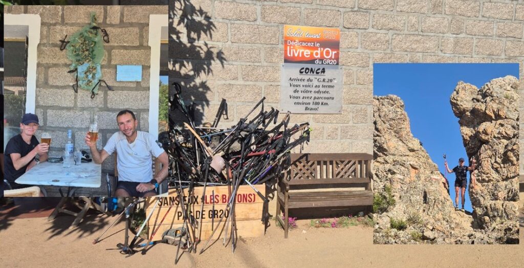
We had crossed Corsica, from north to south, on the toughest trail in Europe. It was the hardest thing I’d ever done, and the most rewarding.